Timothy J Lang

and 21 more

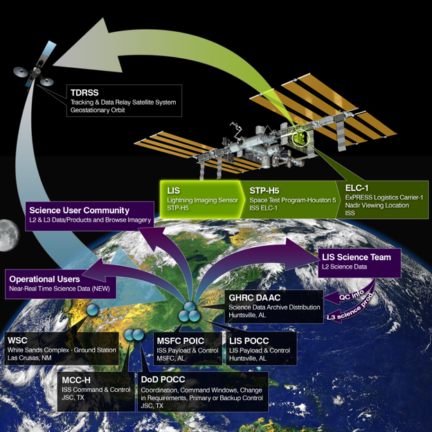
The Lightning Imaging Sensor (LIS) was launched to the International Space Station (ISS) in February 2017, detecting optical signatures of lightning with storm-scale horizontal resolution during both day and night. ISS LIS data are available beginning 1 March 2017. Millisecond timing allows detailed intercalibration and validation with other spaceborne and ground-based lightning sensors. Initial comparisons with those other sensors suggest flash detection efficiency around 60% (diurnal variability of 51-75%), false alarm rate under 5%, timing accuracy better than 2 ms, and horizontal location accuracy around 3 km. The spatially uniform flash detection capability of ISS LIS from low-Earth orbit allows assessment of spatially varying flash detection efficiency for other sensors and networks, particularly the Geostationary Lightning Mappers. ISS LIS provides research data suitable for investigations of lightning physics, climatology, thunderstorm processes, and atmospheric composition, as well as realtime lightning data for operational forecasting and aviation weather interests. ISS LIS enables enrichment and extension of the long-term global climatology of lightning from space, and is the only recent platform that extends the global record to higher latitudes (± 55). The global spatial distribution of lightning from ISS LIS is broadly similar to previous datasets, with globally averaged seasonal/annual flash rates about 5-10% lower. This difference is likely due to reduced flash detection efficiency that will be mitigated in future ISS LIS data processing, as well as the shorter ISS LIS period of record. The expected land/ocean contrast in the diurnal variability of global lightning is also observed.
Lightning is measured from space using optical instruments that detect transient changes in the illumination of the cloud top. How much of the flash (if any) is recorded by the instrument depends on the instrument detection threshold. NOAA’s Geostationary Lightning Mapper (GLM) employs a dynamic threshold that varies across the imaging array and changes over time. This causes flashes in certain regions and at night to be recorded in greater detail than other flashes, and threshold inconsistencies will impose biases on all levels of GLM data products. In this study, we quantify the impact of the varying GLM threshold on event / group detection, flash clustering, and gridded product generation by imposing artificial thresholds on the event data taken from a thunderstorm with a low instrument threshold (~0.7 fJ). We find that even modest increases in threshold severely impact event (60% loss by 2 fJ, 90% loss by 10 fJ) and group (25% loss by 2 fJ, 81% loss by 10 fJ) detection by suppressing faint illumination of the cloud-top from weak sources and scattering. Flash detection is impacted less by threshold increases (4% loss by 2 fJ), but reductions are still significant at higher thresholds (35% loss by 10 fJ, or 44% if single-group flashes are removed). Undetected pulses cause individual flashes to be split and severely impact the construction of gridded products. All these factors complicate the interpretation of GLM data, particularly when trended over time under a changing threshold.
Optical space-based lightning sensors such as the Geostationary Lightning Mapper (GLM) detect and geolocate lightning by recording rapid changes in cloud-top illumination. While lightning locations can be determined to within a pixel on the GLM imaging array, these instruments are not individually able to natively report lightning altitude. It has previously been shown that thunderclouds are illuminated differently based on the altitude of the optical source. In this study, we examine how altitude information can be extracted from the spatial distributions of GLM energy recorded from each optical pulse. We match GLM “groups” with LMA source data that accurately report the 3-D positions of coincident Radio-Frequency (RF) emitters. We then use machine learning methods to predict the mean LMA source altitudes matched to GLM groups using metrics from the optical data that describe the amplitude, breadth, and texture of the group spatial energy distribution. The resulting model can predict the LMA mean source altitude from GLM group data with a median absolute error of < 1.5 km, which is sufficient to determine the location of the charge layer where the optical energy originated. This model is able to capture changes to the source altitude distribution following convective invigoration or maturation, and the GLM predictions can reveal the vertical structure of individual flashes - enabling 3-D flash geolocation with GLM for the first time. Additional work is required to account for differences in thunderstorm charge / precipitation structures and viewing angle across the GLM Field of View.
Previous lightning climatologies derived from Lightning Imaging Sensor (LIS) and Optical Transient Detector (OTD) total lightning measurements have quantified lightning frequency as a Flash Rate Density (FRD). This approach assumes that lightning flashes can be represented as points, and quantifies the frequency of lightning centered in each grid cell. However, lightning has a finite extent that can reach hundreds of kilometers. A new climatology based on Flash Extent Density (FED) is constructed for LIS (including ISS-LIS) and OTD that accounts for the horizontal dimension of lightning. The FED climatology documents the frequency that an observer can expect lightning to be visible overhead - regardless of where the flash began or ended. This new FED climatology confirms and elaborates on the previous global LIS / OTD FRD and Americas-only Geostationary Lightning Mapper (GLM) findings. Applying GLM reprocessing codes to LIS and OTD data reveals cases of megaflashes measured from Low Earth Orbit that were artificially split by the LIS / OTD clustering algorithms. The FED climatology maintains Lake Maracaibo as the global lightning hotspot with an average of 389 flashes / day, but designates Karabre in the Democratic Republic of the Congo as the global thunderstorm duty (percent of the total viewtime where lightning is observed) hotspot at 7.29%. Meanwhile, Kuala Lumpur is the national capital city with the most lightning, and its airport (KUL) is the top major airport affected by lightning. The FED seasonal cycle and month-to-month changes in the “center of lightning” for the three continental chimney regions are also discussed.