Yi Lin

and 1 more

The southeastern margin of the Tibetan Plateau has experienced complex deformation since the Cenozoic, resulting in a high level of seismicity and seismic hazard. Knowledge about the seismic anisotropy provides important insight into the deformation mechanism and the regional seismotectonics beneath this tectonically active region. In this study, we conduct a fullwave multi-scale tomography to investigate the seismic anisotropy in the southeastern margin of the Tibetan Plateau. Broadband records from 470 teleseismic events at 111 permanent stations in the region are used to obtain 5,216 high-quality SKS splitting intensity measurements, which are then inverted in conjunction with 3D sensitivity kernels to obtain the anisotropic model for the region with a multi-scale resolution. Resolution tests show that our dataset recovers anisotropy anomalies reasonably well on the scale of 1º x 1º horizontally and ~100 km vertically. Our result suggests that in the southeastern margin of the Tibetan Plateau the deformations in the lithosphere and asthenosphere are decoupled. The anisotropy in the lithosphere varies both laterally and vertically as a result of the dynamic interactions of neighboring blocks as well as lithospheric reactivation. The anisotropy in the asthenosphere largely follows the direction of regional absolute plate motion, i.e. southeastward under the Songpan-Ganzi Terrane and the Yangtze Craton and nearly east-west south of 26ºN latitude. The SKS splitting observed at the surface can be interpreted as the vertical integration of the contributions from lithosphere and asthenosphere.
To advance the understanding of the tectonic processes shaping the African continent, we construct the first continental-scale shear-wave velocity (Vs) model of the crust and uppermost mantle from joint analysis of ambient seismic noise and earthquake data recorded by ~1529 broadband seismic stations located in Africa, Arabia, and Europe from 1987 to 2018. We apply the widely used ambient noise cross-correlation and earthquake two-station methods to retrieve the fundamental-mode Rayleigh-wave group and phase velocity dispersions in the period range of 5 – 50 s which are jointly inverted using the neighbourhood algorithm to build a new three-dimensional Vs model with associated uncertainties. The inclusion of relatively short-period dispersion data from ambient seismic noise allows us to achieve better resolution at shallow depth and obtain a more accurate model than previous global and continental-scale studies, revealing lithospheric structures that correlate well with known tectonic features. In sparsely instrumented regions of north-central Africa, our model provides seismic evidence for the existence of cratonic remnants beneath thick sediments within the poorly imaged Sahara Metacraton and reveals unique mantle upwelling beneath hotspots, suggesting that they may be fed by unconnected plumes. The estimated crustal thickness varies among and within tectonic provinces and shows no clear evidence for the secular variation in crustal genesis. Our new model has the potential to serve as a preliminary reference velocity model for Africa and is useful for practical applications, including monitoring of the Comprehensive Nuclear-Test-Ban Treaty, geodynamic modeling as well as seismic hazard analysis.

Yijian Zhou

and 9 more

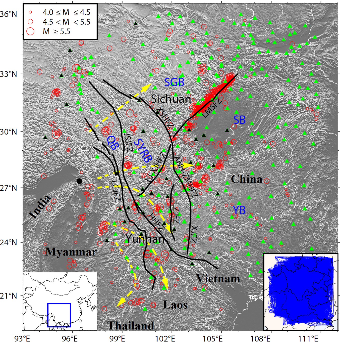
The Xiaojiang Fault (XJF) Zone locates in the southeastern of Tibetan Plateau and defines the boundary between the South China and Sichuan-Yunnan blocks. Historical large earthquakes were hosted on the XJF, though its seismic hazard in the near future is under debate. In this study, we utilize portable broad-band seismic network to unravel the microseismic activities along XJF, and to further investigate the fault structures and their properties. Adopting PALM, a newly developed earthquake detection algorithm, we obtained ~13,000 relocated events. The micro-seismicity reveals widespread off-fault structures showing conjugate geometry, while the major faults present low seismicity. The fault branches conjugate to the main-fault present intensive microseismicity, which hosts repeating events and presents high b-value. Regional GPS stations reflect slips are mostly concentrated along the XJF, while the slip rate on off-fault branches correlates with seismic activities on these structures. Combining with other recent seismological and magnetotellurics evidences, we suggest a low strength on these off-fault structures, which may partially release tectonic stress loading and serve as a barrier for future big earthquakes. On the XJF, the microseismic events are clustered on the fault junctions with low b-value. A special set of clusters between 25°N to 25.5°N show an along-strike variation of depth from 10 to 25-km, imaging the boundary between creeping and locked fault portions. We revisit the seismic hazard problem of XJF, and conclude that XJF is at the late stage of inter-seismic period.

Yuqing He

and 3 more

Intra-continental dip-slip earthquakes often occur in the orogen and rift zones with complex tectonics, providing rare opportunities to illuminate the deformation and evolution of continental structures. However, due to the sparse seismological and geodetic observations, such earthquakes are less studied. Here, we report the fault geometries of two dip-slip earthquakes recently occurred in Southern Tian Shan and the Mongolia-Baikal rift zone revealed by InSAR . The 2020 Mw6.0 Jiashi earthquake occurred in the Keping-tage fold-and-thrust belt in southwest Tian Shan. This region is seismically active, yet most well-recorded earthquakes occurred south of the mountain front. The lack of large earthquakes beneath the belt thus hinders our understanding of the orogenic process to the north. Combining InSAR measurements and relocated aftershocks, we found that a fault model involving a shallow thrust fault and two deeper faults can best reconcile the surface deformation and aftershock distribution. Stress analysis suggests that slips on the shallow fault reactivated the older basement structures at depth. Our results reflect the basement-involved shortening activated by a thin-skinned thrust faulting event with surface deformation, implying a southward orogenic process of the southwest Tian Shan. The 2021 Mw6.7 Lake Hövsgöl earthquake occurred in the Mongolia-Baikal rift zone (MBRZ), which is located in the northern tip of the northern Mongolia, and is bounded by the Tibet Plateau orogenic belt and the Siberian Platform. Using the Bayesian inversion method we derived a fault plane with two slip patches, one is mainly strike slip and the other is mainly normal slip component. The correlation between the observed and predicted displacements by the single fault model is 97.46%. Coulomb stress analysis shows that the 2021 event has a triggering effect on the western segment of the Tunka Fault to the north, where no large earthquakes have occurred since the 1905 M8+ earthquake, raising the potential for seismic risk in this region.

Zhi Wei

and 1 more

We conduct a tomographic inversion for the 3-D P-wave velocity structure in the lower crust and uppermost mantle of the Sichuan-Yunnan region in the southeastern margin of the Tibetan Plateau. A total of 43,450 reliable arrival times of P waves are picked from over 300,000 regional seismic records using an automatic algorithm based on deep learning. A two-stage iterative inversion process is adopted in which events are relocated in the process, leading to a significant reduction in traveltime residuals. A statistical resolution matrix analysis suggests that our model has an optimal spatial resolution length of ~0.4° in the lower crust and ~0.2° in the uppermost mantle. Our 3-D model shows that both the lower crust and uppermost mantle in the region are characterized by strong lateral heterogeneities. The unusually low velocities in the lower crust may indicate the existence of lower crustal flow, whereas the high velocity anomalies in the uppermost mantle in and around the Sichuan-Yunnan Rhombic Block may be an important factor in preventing the ductile materials in the lower crust moving eastward. Our model also indicates a coupling between the surface deformation and the material flow in the lower crust. Finally, the lower crustal flow may influence the materials immediately below the Moho interface beneath the Sichuan-Yunnan Rhombic Block, and the crust-mantle transition zone in the eastern margin of Songpan-Ganzi Block may be influenced by both the lower crustal flow and the upwelling warm materials from below.