The rate of channel incision in bedrock rivers is often described using a power law relationship that scales erosion with drainage area. However, erosion in landscapes that experience strong rainfall gradients may be better described by discharge instead of drainage area. In this study we test if these two end member scenarios result in identifiable topographic signatures in both idealized numerical simulations and in natural landscapes. We find that in simulations using homogeneous lithology, we can differentiate a posteriori between drainage area and discharge-driven incision scenarios by quantifying the relative disorder of channel profiles, as measured by how well tributary profiles mimic both the main stem channel and each other. The more heterogeneous the landscape becomes, the harder it proves to identify the disorder signatures of the end member incision rules. We then apply these indicators to natural landscapes, and find, among 8 test areas, no clear topographic signal that allows us to conclude a discharge or area-driven incision rule is more appropriate. We then quantify the distortion in the channel steepness index induced by changing the incision rule. Distortion in the channel steepness index can also be driven by changes to the assumed reference concavity index, and we find that distortions in the normalized channel steepness index, frequently used as a proxy for erosion rates, is more sensitive to changes in the concavity index than to changes in the assumed incision rule. This makes it a priority to optimize the concavity index even under an unknown incision mechanism.

Emmanuel J. Gabet

and 5 more

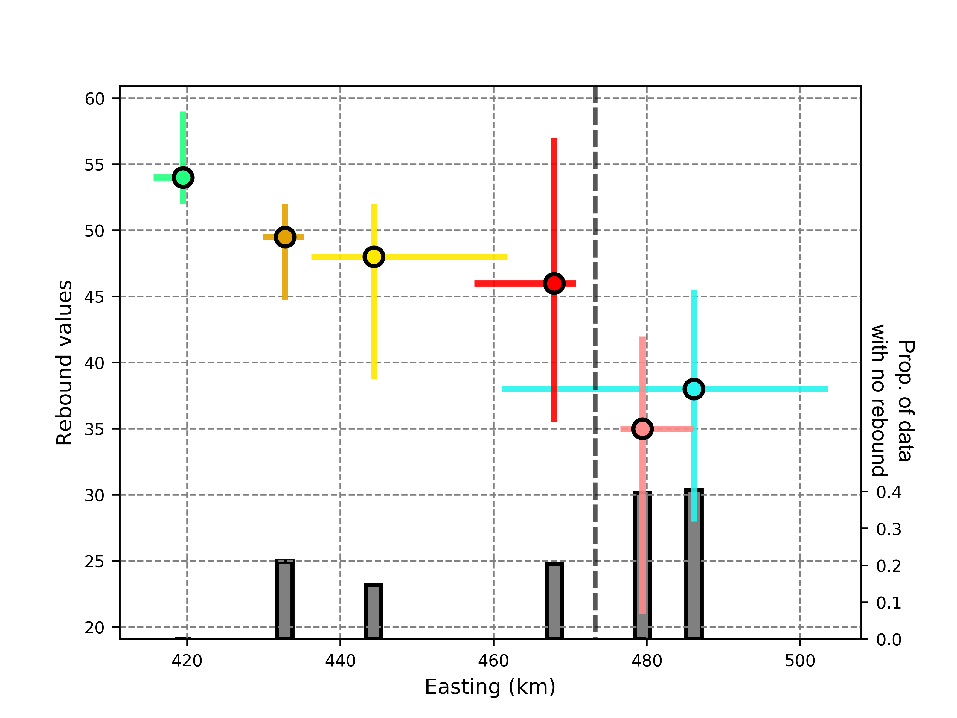
The shape of soil-mantled hillslopes is typically attributed to erosion rate and the transport efficiency of the various processes that contribute to soil creep. While climate is generally hypothesized to have an important influence on soil creep rates, a lack of uniformity in the measurement of transport efficiency has been an obstacle to evaluating the controls on this important landscape parameter. We addressed this problem by compiling a data set in which the transport efficiency has been calculated using a single method, the analysis of hilltop curvatures using 1-m LiDAR data, and the erosion rates have also been determined via a single method, in-situ ¬cosmogenic 10Be concentrations. Moreover, to control for lithology, we chose sites that are only underlain by resistant bedrock. The sites span a range of erosion rates (6 – 922 mm/kyr), mean annual precipitation (39 – 320 cm/yr), and aridity index (0.08 – 1.38). Surprisingly, we find that hilltop curvature varies with the square root of erosion rate, whereas previous studies predict a linear relationship. In addition, we find that the inferred transport coefficient also varies with the square root of erosion rate but is insensitive to climate. We explore various mechanisms that might link the transport coefficient to the erosion rate and conclude that present theory regarding soil-mantled hillslopes is unable to explain our results and is, therefore, incomplete. Finally, we tentatively suggest that processes occurding in the bedrock (e.g., fracture generation) may play a role in the shape of hillslope profiles at our sites.

Boris Gailleton

and 4 more

Fluvial morphology is affected by a wide range of forcing factors, which can be external, such as faulting and changes in climate, or internal, such as variations in rock hardness or degree of fracturing. It is a challenge to separate internal and external forcing factors when they are co-located or occur coevally. Failure to account for both factors leads to potential misinterpretations. For example, steepening of a channel network due to lithologic contrasts could be misinterpreted as a function of increased tectonic displacements. These misinterpretations are enhanced over large areas, where landscape properties needed to calculate channel steepness (\textit{e.g.} channel concavity) can vary significantly in space. In this study, we investigate relative channel steepness over the Eastern Carpathians, where it has been proposed that active rock uplift in the Southeastern Carpathians gives way N- and NW-wards to ca. 8 Myrs of post-orogenic quiescence. We develop a technique to quantify relative channel steepness based on a wide range of concavities, and show that the main signal shows an increase in channel steepness from east to west across the range. Rock hardness measurements and geological studies suggest this difference is driven by lithology. When we isolate channel steepness by lithology to test for ongoing rock uplift along the range, we find steeper channels in the south of the study area compared to the same units in the North. This supports interpretations from longer timescale geological data that active rock uplift is fastest in the southern Southeastern Carpathians.

Boris Gailleton

and 4 more

The concavity index, $\theta$, describes how quickly river channel gradient declines downstream. It is used in calculations of normalized channel steepness index, $k_{sn}$, a metric for comparing the relative steepness of channels with different drainage area. It is also used in calculating a transformed longitudinal coordinate, $\chi$, which has been employed to search for migrating drainage divides. Here we quantify the variability in $\theta$ across multiple landscapes distributed across the globe. We describe the degree to which both the spatial distribution and magnitude of $k_{sn}$ and $\chi$ can be distorted if $\theta$ is assumed, not constrained. Differences between constrained and assumed $\theta$ of 0.1 or less are unlikely to affect the spatial distribution and relative magnitude of $k_{sn}$ values, but larger differences can change the spatial distribution of $k_{sn}$ and in extreme cases invert differences in relative steepness: relatively steep areas can appear relatively gentle areas as quantified by $k_{sn}$. These inversions are function of the range of drainage area in the considered watersheds. We also demonstrate that the $\chi$ coordinate, and therefore the detection of migrating drainage divides, is sensitive to varying values of $\theta$. The median of most likely $\theta$ across a wide range of mountainous and upland environments is 0.425, with first and third quartile values of 0.225 and 0.575. This wide range of variability suggests workers should not assume any value for $\theta$, but should instead calculate a representative $\theta$ for the landscape of interest, and exclude basins for which this value is a poor fit.