Ryo Nakanishi

and 3 more

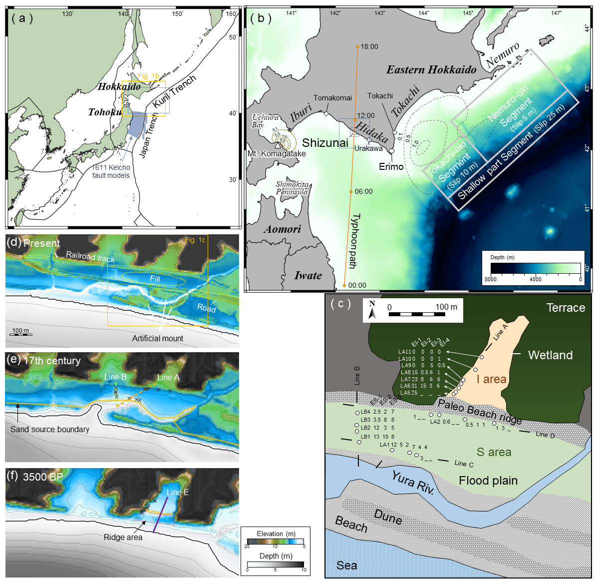
Infrequent megathrust earthquakes, with their complex cycles and rupture modes, require a high-resolution spatiotemporal record of tsunami inundations over thousands of years to provide more accurate long-term forecasts. The geological record suggests that Mw>8 earthquakes in the Kuril Trench occurred at intervals of several hundred years. However, uncertainties remain regarding the rupture zone, owing to the limited survey areas and chronological data. Therefore, we investigated the tsunami deposits in a coastal wetland of southeastern Hokkaido, Japan, to characterize the tsunamis that have originated from the Kuril Trench over the last 4000 years. On the Erimo coast, more than seven sand layers exhibited the common features of tsunami deposits, such as sheet distributions of several hundred meters, normal grading structures, and sharp basal contacts. According to numerical tsunami simulations, the 17th-century sand layer could be reproduced by using a multiple rupture zone model (Mw~8.8). We used high-resolution radiocarbon dating and tephras to correlate the tsunami deposits from the last 4000 years with those reported from regions ~100 km away. The tsunami history revealed here shows good agreement with histories of adjacent regions. However, the paleotsunamis reported to have occurred in regions > 200 km away include some events that differ from those in this study, which suggests a diversity of Mw>8 earthquakes in the Kuril Trench. We clarified the history and extents of earthquake-generated tsunamis along the southwestern end of the Kuril Trench, which were previously unknown. Our results provide a framework for magnitude estimations and long-term forecast of earthquakes.

Atsushi Noda

and 4 more

Ancient exhumed accretionary complexes are sometimes associated with high-pressure–low-temperature (HP–LT) metamorphic rocks, such as psammitic schists, which are derived from sandy trench-fill sediment. At accretionary margins, sandy trench-fill sediments are rarely subducted to the depth of HP metamorphism because they are commonly scraped off at the frontal wedge. This study uses sandbox analogue experiments to investigate the role of seafloor topography in the transport of trench-fill sediment to depth during subduction. The experiments were conducted with a detached, rigid backstop to allow a topographic high (representing a seamount) to be subducted through a subduction channel. In experiments without topographic relief, progressive thickening of the accretionary wedge pushed the backstop down, leading to a stepping down of the décollement, narrowing the subduction channel, and underplating the wedge with subducting sediment. In contrast, in experiments with a topographic high, the subduction of the topographic high raised the backstop, leading to a stepping up of the décollement and widening of the subduction channel. These results suggest that the subduction of topographic relief is a possible mechanism for the transport of trench-fill sediment from the trench to HP environments through a subduction channel. A sufficient supply of sediment to the trench and topographic relief on the subducting oceanic plate might enable trench-fill sediment to be accreted at various depths and deeply subducted to become the protoliths of HP–LT metamorphic rocks.

Hiroaki Koge

and 3 more

Ryo Nakanishi

and 1 more

Sediment transport modeling (STM) is a potentially effective tool for estimating the magnitude of tsunamis and earthquakes without historical records. However, applying STM to prehistorical tsunamis is challenging because of many uncertainties in topography and roughness. In the coast of Hidaka, Hokkaido, Japan, there is potential to conduct STM even in the absence of historical records because of the comprehensive geological data that reveal the coastal evolution during the Holocene in addition to tsunami sediment surveys. The tsunami deposits in Hokkaido suggest the presence of events on a larger scale than historical tsunamis; particularly the 17th-century tsunami had multiple potential wave sources other than a Kuril Trench earthquake, inhibiting its magnitude estimation. In this study, we applied STM to paleotsunamis in the coast of Hidaka, where the wave source is unknown and there are comprehensive geological data. The modeling parameters—paleotopography, roughness, grain size, initial sand source, sea level, and beach ridge height—were estimated using data obtained from geological surveys and sensitivity tests. The modeling of a tsunami induced by a Kuril Trench earthquake reproduced the sediment distributions and sedimentary structures of the observed sand layers better than that of the extreme storm and volcanic tsunami. The paring down wave sources of the sand layer implies that a wider rupture zone in the Kuril Trench is less likely. This case study provides information on the parameters that geologists and modelers should consider when applying STM to paleotsunamis.

Atsushi Noda

and 4 more

We conducted sandbox analogue experiments for subduction of trench-fill sediments beneath accretionary wedge and backstop in order to explain how protoliths of high-pressure/low-temperature (HP-LT) metamorphic rocks are transported to high pressure environment. At accretionary-type subduction zones, it is commonly difficult that coarse-grained sandy trench-fill deposits subduct deeper than high pressure environment (>10 km in depth), because they are accreted at the shallower part of the wedge (<5 km) in association with stepping down of decollement due to progressive dewatering under the accretionary wedge. However, ancient exhumed accretionary complexes sometimes accompany with low-grade accretionary rocks from trench-fill turbidites and HP-LT metamorphic rocks including psammitic and even conglomeratic schists, whose provenance and depositional ages are similar to each other. Therefore, we need a model to explain growth of accretionary wedge and subduction of coarse-grained trench-fill sediments beneath the wedge at the same time. In this study, we attempt to identify an importance of seafloor roughness for transportation of trench-fill sediments to deep during subduction. For this purpose, we performed sandbox analogue experiments by using an unfixed rigid backstop on a subduction channel with the cases of smooth surface (Exp. A) and rough surface representing a seamount or ridge on subducting lower plate (Exp. B). The results of Exp. A showed progressive thickening of the accretionary wedge pushed the backstop down, meaning stepping down of the decollement and narrowing the subduction channel. On the other hand, Exp. B showed a subducting seamount lifted up the backstop, stepped up the decollement, and then widened the subduction channel. Subduction of a rigid material like seamounts is a possible mechanism to open subduction channels for transportation of terrigenous sediments from the trench to high-pressure condition. Significant sediment supply to the trench and rough surface of subducting oceanic plate are required to enable subduction of protolith of HP-LT metamorphic rocks and accretion of trench-fill sediments at the shallow part.

Atsushi Noda

and 4 more

Forearc basin stratigraphy is expected to record a detailed history of the deformation and growth pattern of an accretionary wedge. However, the relationship between syntectonic basin sedimentation and growth of a wedge remains poorly understood, including (1) how deformation of the wedge modifies the basin stratigraphy and (2) how syntectonic sedimentation influences deformation of the wedge. In this study, we conducted scaled analogue sandbox experiments to reproduce accretionary wedges with and without syntectonic sedimentation. The results show that basin stratigraphy varied with the growth pattern of the accretionary wedge. In the case that wedge growth was dominated by trenchward accretion, the depositional area migrated landward. In contrast, prolonged underthrusting caused the sediment layers to be tilted landward and the depocenter to migrate landward. The occurrence of two types of basin stratigraphy (i.e., trenchward and landward migration of the depocenter) reflects a contrast in strength of the basal shear resistance between the inner and outer parts of the wedge due to sedimentation on the wedge. A change in the magnitude of normal stress acting on the wedge base likely influenced the mode of deformation of the wedge. A phase dominated by underthrusting can result in the combining a retro-wedge basin with a wedge-top basin, and yield a wide area of accommodation space in the forearc basin. These results suggest that forearc basin stratigraphy is influenced by the growth pattern of an accretionary wedge that is affected by syntectonic sedimentation.