Matthew Simon

and 4 more

Aim: Ultrafine particles (UFP; <100 nm diameter) are highly variable in space and time and as such can be challenging to model for use in epidemiological studies. Recent studies have shown that airports are contributors to local air pollution, but research is needed to understand the impact from individual aircraft and how to incorporate flight activity into UFP exposure models. Our aim was to characterize UFP transport from aircraft exhaust during landing at Boston Logan International Airport (MA, USA). Methods: Particle number concentration (PNC; a proxy for UFP) was measured continuously on selected weeks at the University of Massachusetts Boston campus from April-September 2017 at 1-sec resolution. The site was positioned 4.8 km southwest of the airport edge and <1 km from a major landing trajectory (runways 4L and 4R). Wind speed and direction were concurrently measured near the UFP monitor at 5-min resolution. For this same monitoring period, flight activity data were acquired from the U.S. Federal Aviation Administration, which included three-dimensional positions of aircraft at approximately 5-sec resolution. All data were merged by timestamp prior to analysis. Results: During times when flights were landing on 4L/R, the 99th percentile of 1-sec PNC during winds from the east (no traffic sources) was 88,000 particles/cm3. The concentration dropped >50% when flights were landing along other trajectories during these same winds. Stratification by wind speed showed that when flights were landing along 4L/R, higher wind speeds resulted in increased median PNC during winds downwind of arrival aircraft, but not from the opposite direction. When flights were landing along other runway trajectories nearly all wind directions observed decreased PNC with increased wind speed. Conclusions: Our results suggest that aircraft can play a role in peak ambient UFP exposures during landing and that downwind transport of UFP from aircraft exhaust needs further investigation.

Keith Spangler

and 11 more

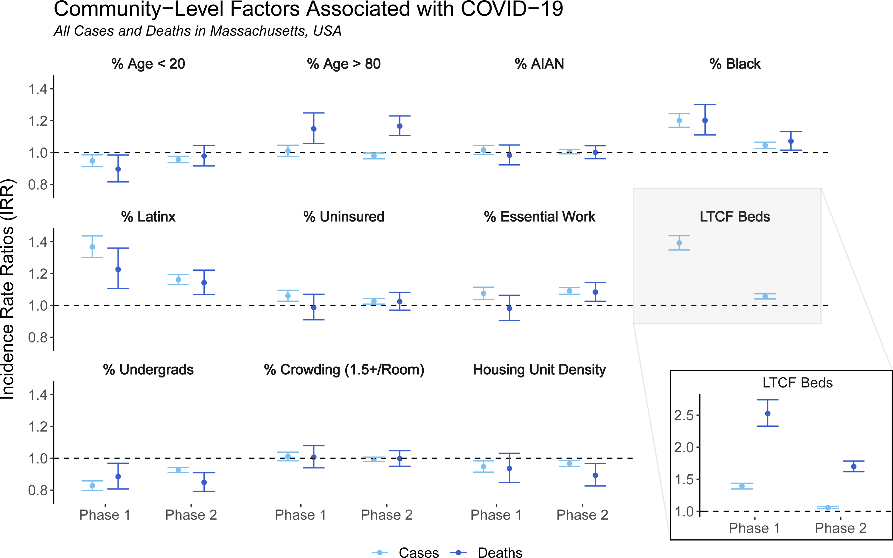
Background: The COVID-19 pandemic has highlighted the need for targeted local interventions given substantial heterogeneity within cities and counties. Publicly available case data are typically aggregated to the city or county level to protect patient privacy, but more granular data are necessary to identify and act upon community-level risk factors that can change over time. Methods: Individual COVID-19 case and mortality data from Massachusetts were geocoded to residential addresses and aggregated into two time periods: “Phase 1” (March–June 2020) and “Phase 2” (September 2020–February 2021). Institutional cases associated with long-term care facilities, prisons, or homeless shelters were identified using address data and modeled separately. Census tract sociodemographic and occupational predictors were drawn from the 2015-2019 American Community Survey. We used mixed-effects negative binomial regression to estimate incidence rate ratios (IRRs), accounting for town-level spatial autocorrelation. Results: Case incidence was elevated in census tracts with higher proportions of Black and Latinx residents, with larger associations in Phase 1 than Phase 2. Case incidence associated with proportion of essential workers was similarly elevated in both Phases. Mortality IRRs had differing patterns from case IRRs, decreasing less substantially between Phases for Black and Latinx populations and increasing between Phases for proportion of essential workers. Mortality models excluding institutional cases yielded stronger associations for age, race/ethnicity, and essential worker status. Conclusions: Geocoded home address data can allow for nuanced analyses of community disease patterns, identification of high-risk subgroups, and exclusion of institutional cases to comprehensively reflect community risk.