Zengming Ke

and 5 more

Water shortage and soil salinization in gully farmland comprising sediment deposited farmland (SF) and excavated farmland (EF) have become a widespread concern in the loess hilly region. A two-year field experiment was conducted to assess the soil water content (SWC) and salt content (SSC) and their effect on the spring maize yield and water use efficiency in SF and EF. Eight treatments comprising flat cropping without mulching (1), ridge planting without mulching (2), ridge planting with plastic mulching (3), and ridge planting with straw mulching (4) were tested in the SF and EF plots, respectively. The results showed that the yield was higher in SF than EF, whereas the water use efficiency was significantly higher in EF because the bottom water flux was 117.4% higher in SF than EF (P < 0.01). A significant positive correlation was found between the average SWC and yield (P < 0.01), thereby indicating that the yield was severely limited by the SWC. Thus, the higher water use efficiency in EF has important implications for alleviating water scarcity during agricultural production in this region. The risk of soil salinization was decreased greatly by treatment 3 where the SSC was decreased in EF and SF were 0.09 g kg–1 and 0.08 g kg–1, respectively. In addition, treatment 3 had the most significant impacts on the yield and water use efficiency. Our study provided appropriate land type and effective tillage measure for the sustainable development in dryland agricultural areas.

Zengming Ke

and 6 more

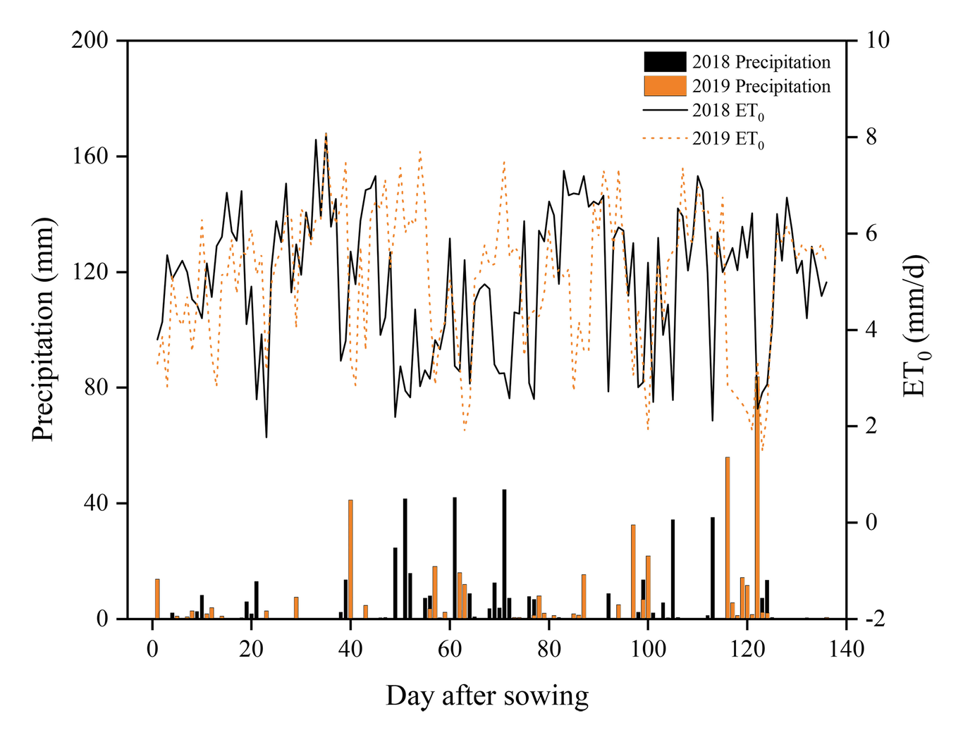
Abstract: Long-term soil salt accumulation could lead to salinization. Aimed to prevent soil salinization, we investigated soil salt dynamics, its interface with the groundwater table, rainfalls duration and the impact periods when salt is mostly accumulated. Total soil salt accumulation and dynamic distribution were monitored in the 0–80 cm layer in alluvial farmland from 2018 to 2020. We found soil salt contents increased by 0.15 g kg–1 and 0.07 g kg–1 in the 0–40 and 40–80 cm soil layers, respectively, which indicated that soil salinization occurred. We defined the rainstorm impact period (RIP) as period when soil salt dynamic distribution was affected by rainstorm event. The salinity time-trend during RIP was sequentially characterized by a first salt leaching, followed by a rapid and then slow salt accumulation, which took the first 4 days, from day 4 to 10, and then beyond, respectively. In the first leaching stage, salt migration content was determined by rainfall (P < 0.05) which could leach 41.5% of salt on average in the whole soil layer. In the rapid accumulation stage, lots of salt accumulated due to high evapotranspiration and shallow groundwater table. In the slow accumulation stage, salt accumulation rate was inhibited by deeper groundwater table. In addition, the total accumulated soil salt in the whole soil layer increased by 0.14 g kg–1 in the RIPs, which comprised only 14.5% of the overall study period, but the value accounted for 63.6% of the salt accumulation, thereby indicating that RIPs were the main periods when salt accumulated during the soil salinization process. Our results provided insights into soil salt dynamic distribution during RIPs, thereby facilitating the effective prevention and control of soil salinization.

Zengming Ke

and 7 more

It is important to study the mechanisms associated with the spatial distribution of soil water and salt to control soil salinization and promote the sustainable development of farmland. In this study, six plots in gully farmland in the loess hilly region with different spatial locations were selected to determine the spatial distributions of soil water and salt and their correlation using the multifractal method. A grid method (15 m  15 m, 3,600 m2) was applied in the 0–20 and 20–40 cm soil layers where each sampling site was located at the center point coordinates. The results showed that the spatial variability of the soil water and salt were 1.41 and 1.73 times higher, respectively, in the upstream farmland than the downstream farmland. The uneven runoff and sediment distributions from gullies in the upstream farmland increased the spatial variability of the soil water and salt. In addition, the vulnerability of upstream farmland to waterlogging caused further in their spatial variability due to narrow landform features. Analysis using the joint multifractal method showed that the spatial variability of the soil water and salt was strongly correlated (P < 0.05) because of the coupling between soil water and salt. In addition, the spatial variability of the soil water and salt was strongly correlated in the 0−20 and 20−40 cm layers because of the spatial autocorrelations of the soil properties (P < 0.05), thereby indicating that the spatial distributions of soil water and salt in the whole soil layer could be represented by those in the 0−20 cm layer. Thus, we recommend using the 0−20 soil layer to sample the distributions of the soil water and salt. Our results provide a theoretical basis for studying the interactive mechanisms associated with the distributions of soil water and salt, and for optimizing the sampling method in the study area.