Soil erosion is an important problem in the loess landscapes of Europe, resulting in a lowering of soil quality and landscape changes. As a result of soil erosion, SOC is redistributed and stored in SOC pools within the landscape. Understanding the SOC dynamics is important because changes in the SOC stocks may have large impacts on global climate change. Closed depressions (CDs) in loess landscapes collect colluvial sediments resulting from soil erosion and constitute sediment stores enabling the calculation of soil erosion phases and rates. CDs are also SOC pools enabling assessing of SOC erosion and storage in loess landscapes over long periods. Colluvial sediments and fossil soils, infilling five representative CDs in the Polish loess areas used for agriculture during several millennia, were documented. The mean SOC content in CDs were calculated, the area of CDs at the regional scale were mapped. Between 11.66 and 31.78 Mg of SOC are stored in each CD. The SOC within CDs represents a significant SOC storage in the landscape of the studied region and can reach values between 178.96 and 206.73 Mg·ha-1(mean 192.85 Mg·ha-1), the SOC content in the soil cover of the surrounding eroded slopes and plateaus is 102.38 Mg·ha-1. This study indicates that CDs are a key morphological features for a better understanding of the spatial distribution of SOC in agricultural used loess landscapes of eastern Poland. SOC storage in CDs needs to be taken into account when calculating total soil carbon storage at the regional scale.
Land degradation due to soil erosion presents a challenge for sustainable development. We investigated the impact of land use type and land management practices on runoff and sediment yield dynamics in the northwestern highlands of Ethiopia. The study area included 14 zero-order catchments with a surface area ranging from 324 m2 to 1715 m2. V-notch weirs produced from plastic jars were introduced as measuring alternatives that met local constraints. Runoff depth at the weir was registered at 5-min intervals during two rainy seasons in 2018 and 2019. Rainfall was measured using tipping-bucket rain gauges. Runoff samples were collected in 1-L bottles and suspended sediment concentration (SSC) was determined. The mean event runoff coefficient ranged from 3% for forests to 56% for badlands. Similarly, the mean annual sediment yield (SY) was lowest for forests (0.8 Mg ha-1 yr-1) and highest for badlands (43.4 Mg ha-1 yr-1), with significant differences among land use types (14.8 Mg ha-1 yr-1 in cropland, 5.7 Mg ha-1 yr-1 in grazing land, and 2.9 Mg ha-1 yr-1 in plantations). Soil organic matter (SOM) reduced runoff and SY, necessitating the consideration of agronomic and land management practices that enhance SOM. Annual SY decreased exponentially with the rock fragment cover (RFC). In fields where RFC was less than 20%, collecting rock fragments for installing stone bunds resulted in a net increase in SY. Rehabilitating badlands and enhancing SOM content in croplands can substantially reduce catchment SY and, hence considerably contribute to the sustainability of this type of environment.

Oleg P. Yermolayev

and 4 more

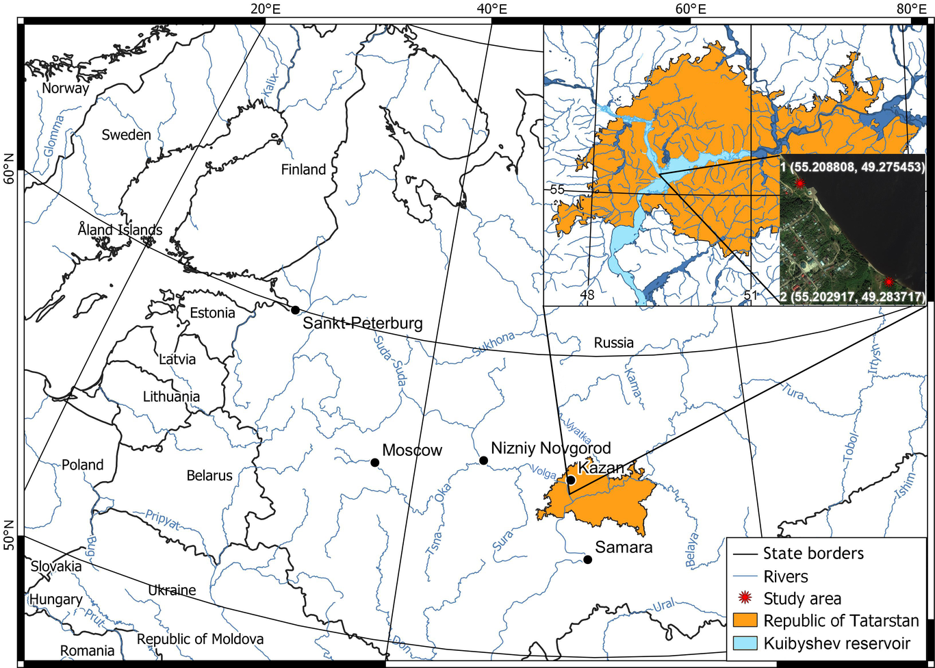
The study object is the Kuibyshev reservoir. The objective is to quantitatively assess reservoir bank landslides and shoreline abrasion in active zones based on the integrated use of modern instrumental methods. Different approaches are used to assess the intensity of landslide and abrasion processes: the specific volume and material loss index, the planar displacement of the bank scarp, and the planar-altitude analysis displacements of soil masses based on the analysis of slope profiles. Shoreline position for the past periods (1958, 1985, and 1987) was obtained from archival aerial photography data; data for 1975, 1993, 2010, 2011, and 2012 were obtained from high-resolution satellite image interpretation. Field surveys of these geomorphic processes at the study areas in 2002, 2003, 2005, 2006, 2014 were carried out using total stations; in 2012-2014 using terrestrial laser scanning and a UAV survey in 2019. The monitoring of landslide processes showed that the rate of volumetric changes at Site 1 remained rather stable during the measurement period with net material losses of 0.03-0.04 m3/m2/year. The most significant contribution to the average annual value of material loss was by snowmelt runoff. The landslide scarp retreat rate at Site 2 showed a steady decreasing trend, due to partial overgrowth of the landslide accumulation zone resulting in its relative stabilization. The average long-term landslide scarp retreat rate is 2.3 m/year. In recent years, landslide control measures realized at this site have reduced the landsliding intensity by more than 2.5 times to 0.84 m/year