Chi Zhang

and 3 more

Total evaporation from the vast terrain of the Tibetan Plateau (TP) may strongly influence downwind regions. However, the ultimate fate of this moisture remains unclear. This study tracked and quantified TP-originating moisture. The results show that the TP moisture participation in downwind regions’ precipitation is the strongest around the eastern edge of the TP and then weakens gradually toward the east. Consequently, TP moisture in the composition of precipitation over the central-eastern TP is the largest of over 30%. 44.9-46.7% of TP annual evaporation is recycled over the TP, and about 2/3 of the TP evaporation is reprecipitated over terrestrial China. Moisture cycling of TP origin shows strong seasonal variation, with seasonal patterns largely determined by precipitation, evaporation and wind fields. High levels of evaporation and precipitation over the TP in summer maximize local recycling intensity and recycling ratios. Annual precipitation of TP origin increased mainly around the northeastern TP during 2000-2020. This region consumed more than half of the increased TP evaporation. Further analyses showed that changes in reprecipitation of TP origin were consistent with precipitation trends in nearby downwind areas: when intensified TP evaporation meets intensified precipitation, more TP moisture is precipitated out. The model estimated an annual precipitation recycling ratio (PRR) of 26.9-30.8% in forward moisture tracking. However, due to the non-closure issue of the atmospheric moisture balance equation, the annual PRR in backward tracking can be ~6% lower.

Yongqiang Zhang

and 7 more

Because remote sensing (RS) data are spatially and temporally explicit and available across the globe, they have the potential to be used for predicting runoff in ungauged or poorly gauged catchments, a challenging area of research in hydrology over the last several decades. There is potential to use remotely sensed data for calibrating hydrological models in regions with limited streamflow gauges. This study conducts a comprehensive investigation on how to incorporate gridded remotely sensed-evapotranspiration (AET) and water storage data for constraining hydrological model calibration in order to predict daily and monthly runoff in 30 catchments of Yalong River basin, China. To this end, seven RS data calibration schemes are explored, compared to traditional calibration against observed runoff and traditional regionalization using spatial proximity. Our results show that using bias-corrected remotely sensed AET (bias-corrected PML-AET data) for constraining model calibration performs much better than using the non bias-corrected remotely sensed AET data (non bias-corrected AET obtained from PML model estimate). Using the bias-corrected PML-AET data in a gridded way is much better than that in a lumped way, and outperforms the traditional regionalization approach especially at upstream and large catchments. Combining the bias-corrected PML-AET and GRACE water storage data performs similarly to using the bias-corrected PML-AET data only. This study demonstrates that and there is great potential to use RS-AET based data for calibrating hydrological models in order to predict runoff in data sparse regions with complex terrain conditions.

Lei Huang

and 7 more

Evapotranspiration (ET) is the major component of the hydrology cycle. Satellites provide a convenient way for gathering information to estimate regional ET. The most widely applied method for converting the instantaneous satellite measurement to daily scale assumes that evaporative fraction (EF), defined as the ratio of ET to the available energy, is constant during the daytime. However, this method was proved to underestimate the daily ET. This study implemented a theoretically improved EF algorithm to calculate daily ET with the decoupling factor method based on the Penman-Monteith and McNaughton-Jarvis equations. Seven improved algorithms were developed by assuming that various parameters remain constant during the day. The satellite-based ET estimates were compared with seven local flux tower measurements in China. The results showed that: (1) The original ET method calculated the daily evaporation more accurately than the other algorithms. However, the good fit was based on two compensating inaccuracies. Compared to the flux tower measurement, the original ET method underestimated the daily EF by 26% and overestimated the daily net radiation by 30%. (2) Six of the seven proposed algorithms underpredicted the daily ET by 30-60%, mainly due to the inaccurate daily net radiation. (3) The algorithm that assumed that the instantaneous decoupling parameter Ω* was equal to its daily value method calculated EF and ET with the relative errors of 8% and 10% when the inaccurate estimated daily net radiation was replaced by the observed flux tower data.

Qi Huang

and 7 more

Because remote sensing (RS) data are spatially and temporally explicit and available across the globe, they have the potential to be used for predicting runoff in ungauged catchments and poorly gauged regions, a challenging area of research in hydrology. There is potential to use remotely sensed data for calibrating hydrological models in regions with limited streamflow gauges. This study conducts a comprehensive investigation on how to incorporate gridded remotely sensed evapotranspiration (AET) and water storage data for constraining hydrological model calibration in order to predict daily and monthly runoff in 30 catchments in the Yalong River basin in China. To this end, seven RS data calibration schemes are explored, and compared to direct calibration against observed runoff and traditional regionalization using spatial proximity to predict runoff in ungauged catchments. The results show that using bias-corrected remotely sensed AET (bias-corrected PML-AET data) for constraining model calibration performs much better than using the raw remotely sensed AET data (non-bias-corrected AET obtained from PML model estimate). Using the bias-corrected PML-AET data in a gridded way is much better than using lumped data, and outperforms the traditional regionalization approach especially in headwater and large catchments. Combining the bias-corrected PML-AET and GRACE water storage data performs similarly to using the bias-corrected PML-AET data only. This study demonstrates that there is great potential in using bias-corrected RS-AET data to calibrating hydrological models (without the need for gauged streamflow data) to estimate daily and monthly runoff time series in ungauged catchments and sparsely gauged regions.

Kidane Reda

and 4 more

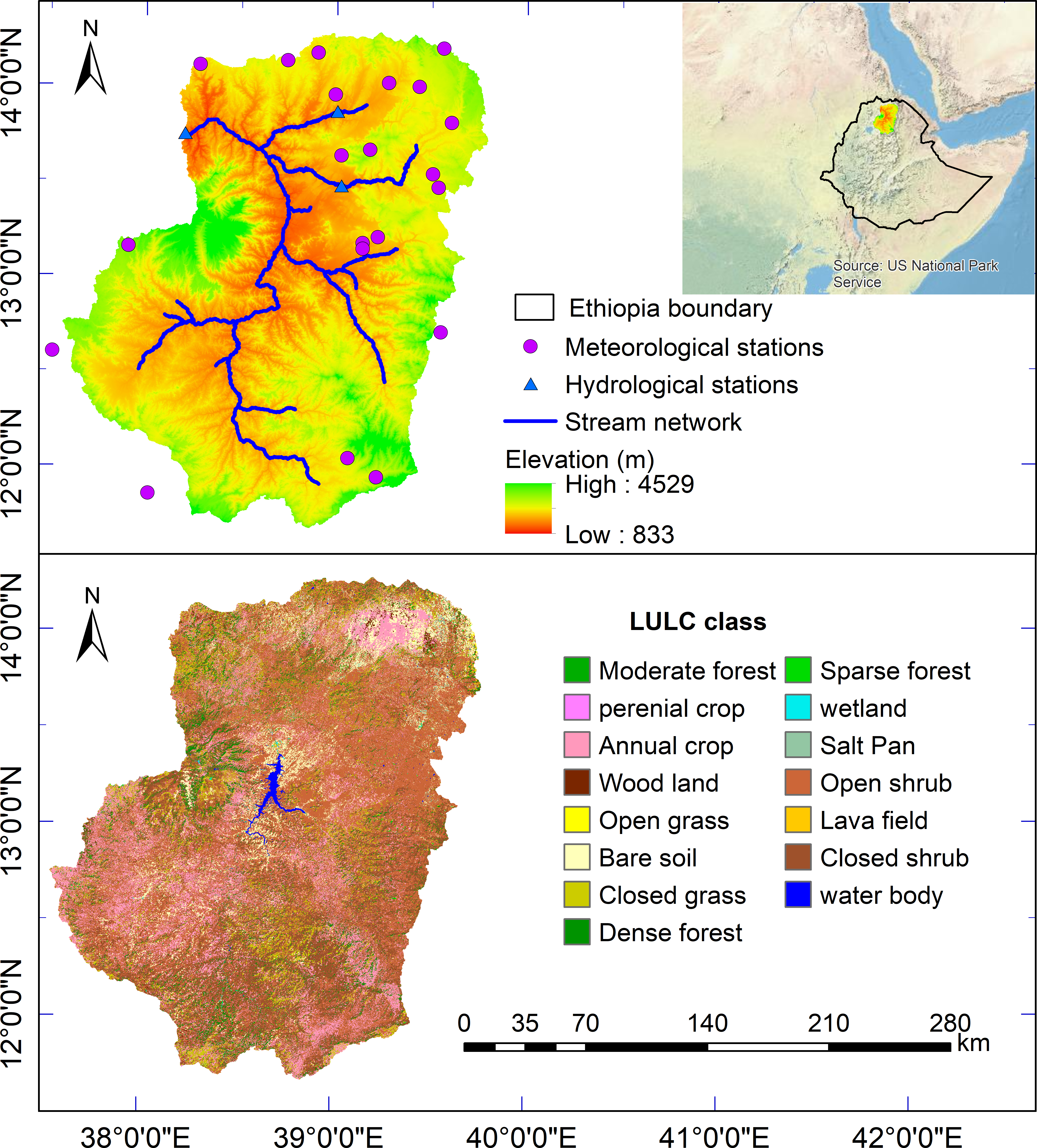
Spatial rainfall data is an essential input to physically based, parametrically distributed hydrological models, and a main contributor to hydrological model uncertainty. Two important issues should be addressed before use of satellite and reanalysis rainfall product at basin level: 1) how useful are these rainfall estimates as forcing data for regional hydrological modeling? 2) which should be preferred for hydrological modelling at high flow and low flow seasons? To this end, rainfall estimates from a satellite-based product, CHIRPSv8, and reanalysis data, EWEMBI, were used as input to SWAT model, and mode performances were evaluated against streamflow measured at three gauge stations in the Upper Tekeze River basin, northern Ethiopia for the period of 2006-2015. Results showed that (I) the daily rainfall from both CHIRPSv8 and EWEMBI are close to the rain gauge data, with relative errors 2.12% and 3.85%, respectively; (II) the monthly streamflow simulated by the SWAT model driven by the CHIRPSv8 and EWEMBI had a Kling-Gupta Efficiency value of 0.6-0.79 and 0.58-0.64, respectively; (III) the SWAT model calibrated with the CHIRPSv8 and EWEMBI rainfall estimates has shown an improvement in hydrological performance compared with that calibrated with interpolated ground observations; (IV) the hydrological performance during high flow seasons is superior to low flow seasons for both CHIRPSv8 and EWEMBI, thus promoting the use of the products for applications focusing on the high flow conditions. In particular, CHIRPSv8 showed relatively better hydrologic performance than EWEMBI. This study provides insight on the usefulness of the gridded rainfall products for hydrological modeling and under which conditions they can be used to generate a plausible level of adequacy and reliability over the Upper Tekeze River basin.