XiXi Lu

and 7 more

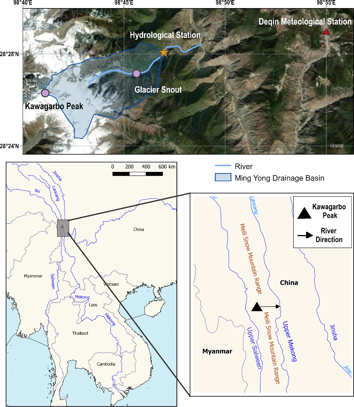
Glacial and proglacial erosion are important sediment sources in a river basin. The retreat of many glaciers on the Tibetan Plateau has important implications on the supply of fresh water and sediment dynamics for downstream river basins. Despite the importance of water and sediment dynamics at these catchments, existing quantification of suspended sediment fluxes from glacial catchments on the Tibetan Plateau is limited due to poor accessibility and challenging environments. This study presents the results of in-situ investigations of water discharge and suspended sediment fluxes from the Ming Yong glacial catchment in Yunnan, Southwest China, between August 2013 and July 2017. The results show that the variation in water discharge and suspended sediment was highly seasonal. The variation of average suspended sediment concentration was large – 69±45 mg/L; 119±104 mg/L; 94±97 mg/L in 2013, 2015, 2016, respectively. We estimate that the sediment yield from Ming Yong catchment was highly variable ranging from 1104 t/km 2/year in 2013to 2281 t/ km 2/year in 2016, with 65-78% of the total annual sediment load occurring during summer (June to August). These annual variations in the sediment yield can be attributed largely to precipitation patterns, or otherwise, extreme melting events. This study has provided a benchmark dataset that can be used for further works that investigate the impact of climate change on sediment dynamics in glacierized catchments in the Tibetan Plateau. Subsequently, the study let us better understand the increasing sediment supply to the Upper Mekong River from glacierized catchments.

XiXi Lu

and 1 more

While 1992 marked the first major dam – Manwan – on the main stem of the Mekong River, the post-2010 era has seen the construction and operationalisation of mega dams such as Xiaowan (started operations in 2010) and Nuozhadu (started operations in 2014) that were much larger than any dams built before. The scale of these projects implies that their operations will likely have significant ecological and hydrological impacts from the Upper Mekong Basin to the Vietnamese Delta and beyond. Historical water level and water discharge data from 1960 to 2020 were analysed to examine the changes to streamflow conditions across three time periods: 1960-1991 (pre-dam), 1992-2009 (growth) and 2010-2020 (mega-dam). At Chiang Saen, the nearest station to the China border, monthly water discharge in the mega-dam period has increased by up to 98% during the dry season and decreased up as much as -35% during the wet season when compared to pre-dam records. Similarly, monthly water levels also rose by up to +1.16m during the dry season and dropped by up to -1.55m during the wet season. This pattern of hydrological alterations is observed further downstream to at least Stung Treng (Cambodia) in our study, showing that Mekong streamflow characteristics have shifted substantially in the post-2010 era. In light of such changes, the 2019-2020 drought – the most severe one in the recent history in the Lower Mekong Basin – was a consequent of constructed dams reducing the amount of water during the wet season. This reduction of water was exacerbated by the decreased monsoon precipitation in 2019. Concurrently, the untimely operationalisation of the newly opened Xayaburi dam in Laos coincided with the peak of the 2019-2020 drought and could have aggravated the dry conditions downstream. Thus, the mega-dam era (post-2010) may signal the start of a new normal of wet-season droughts.