dexun Qiu

and 3 more

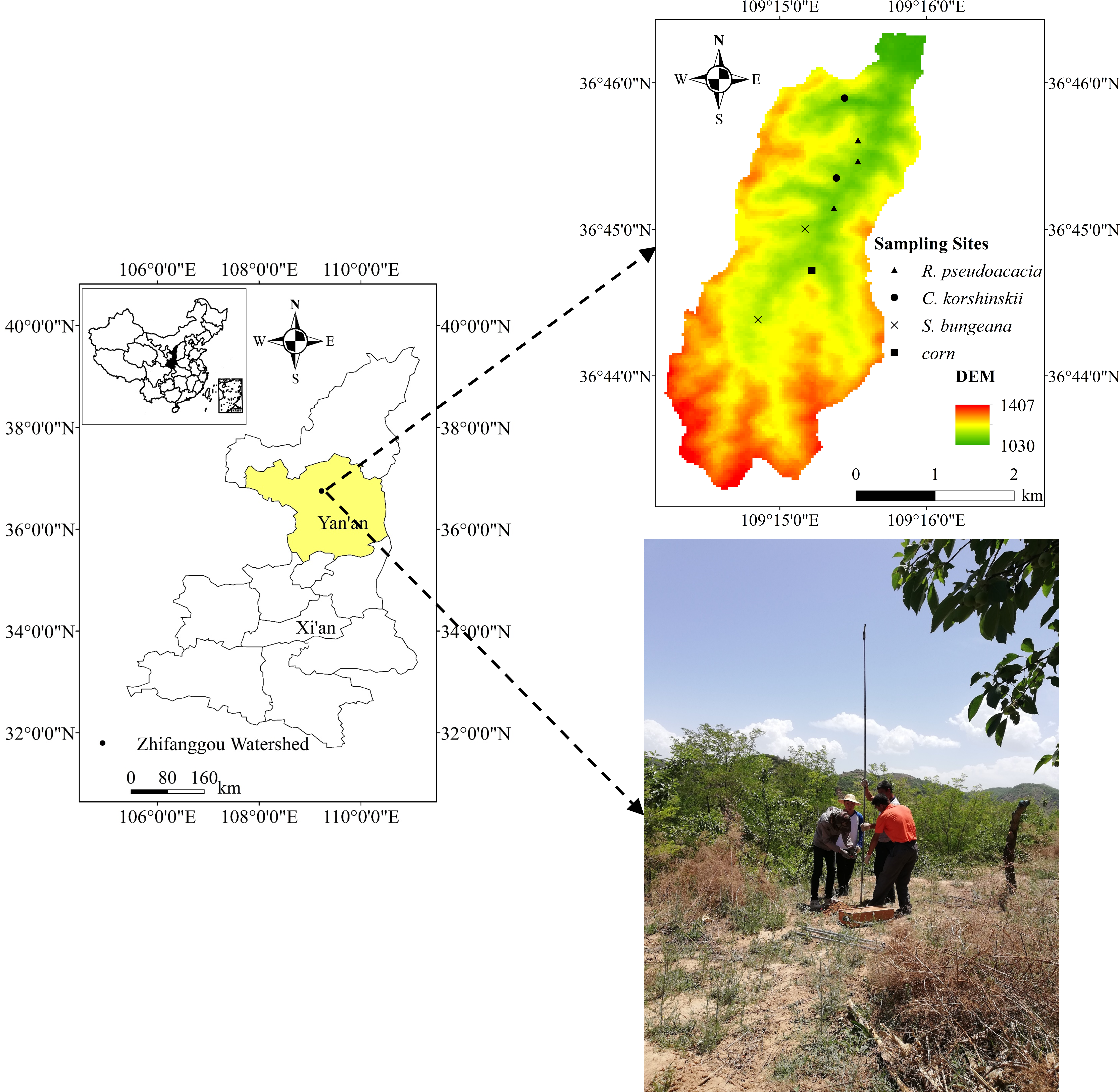
Soil moisture is essential for vegetation restoration in arid and semi-arid regions. Ascertaining the vertical distribution and transportation of soil moisture under different vegetation restoration types has a profound impact on the ecological construction. In this study, the soil moisture at a depth of 500 cm for four typical vegetation types, including R. pseudoacacia (forestland), C. korshinskii (shrubland), S. bungeana (abandoned land), and corn (cropland) were investigated and compared in the Zhifanggou watershed of Loess plateau, China. Additionally, hydrogen and oxygen stable isotopes were detected to identify and reflect the characteristics of soil water. The results showed vertical distribution and transportation of soil moisture have different variations under different vegetation types. Depth-averaged soil moisture under S. bungeana and corn increased along the profile as a whole, while C. korshinskii and R. pseudoacacia showing a trend of weakly increasing and relatively stable state after an obvious decreasing trend (0–40 cm). The mean soil moisture under R. pseudoacacia is lower than other types, especially in deeper layers. In addition, it was observed that the longer vegetation age, the lower mean soil moisture, while this phenomenon was unobvious in S. bungeana. Planting arbor species such as R. pseudoacacia intensified the decline of soil moisture in the Loess Plateau, this limited the growth of arbor species in turn. The capacity of evaporation fractionation of soil moisture followed the sequence: corn > S. bungeana > R. pseudoacacia > C. korshinskii. Profiles of δ18O values of soil moisture under different vegetation types are quite different. On the whole, the δ18O values varied greatly in upper soil layers and tend to be consistent with the increase of soil depth. We estimate that piston flow is the main mode of precipitation infiltration, and the occurrence of preferential flow is related to vegetation types. These results are expected to help improve the understanding of the response of deep soil moisture to vegetation restoration and inform practices for sustainable water management.

Changxue Wu

and 5 more

Wei River is the largest tributary of the Yellow River, and in recent decades, water resource has changed significantly. Identifying the characteristics and influencing factors of streamflow change in Wei River is needed for development of effective management strategies and economic development for the region and entire Yellow River basin. The analyzations were based on streamflow records from 1957 to 2018 at five hydrological stations as well as precipitation and air temperature data from 22 meteorological stations. Mann-Kendall method and Pettitt test were used to analyze trends and transition years of hydrometeorological variables. Double mass curves (DMC) were used to quantify the impact of climate changes and anthropogenic activities on streamflow change. The results showed that: the annual average streamflow decreased significantly in the upper reaches (URWR), middle reaches (MRWR) of the main Wei River, Jing River Basin (JRB), Beiluo River Basin (BLRB) as well as the whole Wei River Basin (WWRB). There were transition years existed in these reaches and concentrated in 1990s. The annual precipitation showed a significant downward trend in the MRWR, LRWR, BLRB and WWRB (P<0.01). Air temperature in all reaches rise significantly (P<0.01). Analysis of land use from 1980 to 2020 indicated that residential land and grassland increased markedly. The results of DMC showed that anthropogenic activities were the dominant factors for streamflow reduction, accounting for 52.96%-92.2%. For different reaches, the intensity of human activities (domestic water, agricultural irrigation, industrial water, soil and water conservation measures and reservoirs construction, etc.) was different, resulting in the difference of contribution rate. Relevant research results provide basis for scientific regulation of water resources in Wei River Basin.

yu luo

and 3 more

Potential evapotranspiration (ET0) is an important expenditure item in the hydrological cycle. Quantitative estimation of the influence of meteorological factors on ET0 can provide a scientific basis for the study of the impact mechanism of climate change on the hydrological cycle. In this paper, the Penman-Monteith method was used to calculate ET0. The Mann-Kendall statistical test and the Inverse Distance Weighting method were used to analyze the temporal and spatial characteristics of the sensitivity coefficient of ET0 to meteorological factors and contribution rate of meteorological factors to ET0. And the reasons for the change of ET0 were quantitatively explored in combination with the change trend of meteorological factors. The results showed that the average ET0 in the Yanhe River Basin from 1978 to 2017 was 935.92mm. Except for Ganquan Station, ET0 showed an upward trend. Generally, the sensitivity coefficient of air temperature (0.08), wind speed (0.19) and solar radiation (0.42) was positive and the sensitivity coefficient of relative humidity (-0.41) was negative. But there were significant temporal and spatial differences. The upward trend of air temperature and solar radiation contributed 1.09% and 0.55% to ET0. Respectively, the downward trend of wind speed contributed -0.63% And the downward trend of relative humidity contributed to -0.85% of ET0. Therefore, the decrease of relative humidity did not cause the increase of ET0 in Yanhe River basin. The dominant factor of the upward trend of ET0 was air temperature. But the dominant factors of ET0 had significant temporal and spatial differences. The downward trend of wind speed at Ganquan Station contributed -9.16% to ET0, which indicated the dominant factor of “evaporation paradox” in Ganquan area was wind speed. Generally, the increase of ET0 was related to air temperature, wind speed and solar radiation. And the decrease of ET0 was related to relative humidity.