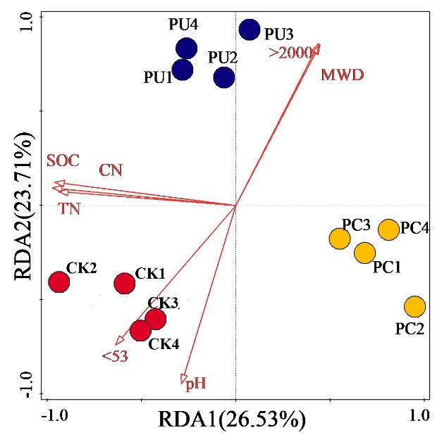
Boyang Liu

and 6 more

Ephemeral gully erosion is a primary mode of soil erosion that is highly visible, affecting soil productivity and restricting land use. Watershed is the basic unit of soil erosion control; existing research has focused on several typical ephemeral gullies or slopes, which do not fully display changes in ephemeral gullies at a watershed scale. This study analyzed the spatial-temporal evolution and development rate of ephemeral gully erosion at the watershed scale on the Loess Plateau from 2009 to 2021 using remote sensing images (0.5 m resolution), unmanned aerial vehicles (UAV), and field investigations. The results revealed that: (1) most ephemeral gullies occurred in southwestern parts of the watershed, with many hills and large slope gradients; (2) average growth rates of each ephemeral gully frequency, length, density, dissection degree, and width were 2.87 km 2 y –1, 1.66 m y –1, 0.12 km km –2 y –1, 0.0125% y –1, and 0.04 m y –1 , respectively; (3) ephemeral gully erosion volume ( V) and length ( L) had a good power function relationship: V = 0 . 0842 L 1 . 1932   ( R 2 = 0 . 80 ) . The root mean square error (RMSE) and coefficient of determination (R 2) between the measured and predicted ephemeral gully volumes suggest that the V–L relationship has a good predictive ability for ephemeral gully volume. Thus, the V–L model was used to evaluate the development rate of ephemeral gully erosion volume in small watersheds from 2009 to 2021, revealing an average value of 743.20 m 3 y –1. This study proposed a feasible model for assessing ephemeral gully volume and volume changes at a watershed scale using high-resolution remote sensing images, providing a reference for understanding the development of ephemeral gully erosion in small watersheds over time.

Liuyang Yu

and 5 more

Partitioning evapotranspiration (ET) into evaporation (E) and transpiration (T) is essential for understanding the global hydrological cycle and improving water resource management. However, ET partitioning in various ecosystems is challenging as some assumptions are restricted to certain areas or plant types. Here, we developed a novel ET partitioning method coupling definitions of leaf and ecosystem water use efficiencies (WUEleaf and WUEeco, respectively). We used 25 eddy covariance flux sites for 196 site-years to evaluate T:ET characteristics of seven plant functional types (PFTs) at different spatiotemporal scales. The results indicated the spatiotemporal characteristics of WUEleaf and WUEeco were not consistent, resulting in T:ET variation in the seven PFTs. Deciduous broadleaf forests had the highest mean annual T:ET (0.67), followed by evergreen broadleaf forests (0.63), grasslands (0.52), evergreen needleleaf forests (0.46), and woody savanna (0.41), and C3 croplands had higher T:ET (0.65) than C4 croplands (0.48). The annual mean leaf area index (LAI) explained about 26% of the variation in T:ET, with the trend in T:ET consistent with the known effects of LAI. The overall trends and magnitude of T:ET in this study were similar to different results of ET partitioning methods globally. Importantly, this method improved T:ET estimation accuracy in vegetation-sparse and water-limited areas. Our novel ET partitioning method is suitable for estimating T:ET at various spatiotemporal scales and provides insight into the conversion of WUE at different scales.

Boyang Liu

and 6 more

Gully erosion is one of the main modes of slope erosion on the Loess Plateau, which plays a connecting role in the slope gully erosion system. The Loess Plateau has wide and densely distributed gullies. The study selected a typical small watershed in the hilly and gully region of the Loess Plateau to measure the morphological characteristics and spatial-temporal distribution of gullies. A deep learning image semantic segmentation model was used to identify and extract the morphological features of gullies at the watershed scale from 2009 to 2021 based on remote sensing images (0.5 m resolution) and then analyze their temporal and spatial distribution characteristics. The results revealed that: (1) most gullies occurred in the hilly southern parts of the watershed, which has complex landforms and large slope gradients; (2) gully number increased from 1,159 in 2009 to 2,312 in 2021 (average 97 per year), with a frequency development rate of 2.87 km –2 y –1; (3) gully length generally ranged from 25–40 m, with an average growth rate is 1.66 m y –1 and density development rate of 0.12 km km –2 y –1; (4) gully width ranged from 0.5–1.5 m, with an average growth rate of 0.04 m y –1. (5) the total gully area increased from 0.0566 km² in 2009 to 0.1072 km² in 2021, with a development rate of 4,213.39 m² y –1 and dissection degree development rate of 0.0125% y –1. This study provides a theoretical and scientific basis for gully erosion control and eco-environmental protection at the watershed scale on the Loess Plateau.

Biao Zhang

and 6 more

Extreme meteorological events occur frequently, and changes in the spatial pattern of land use have greatly affected the soil erosion process in the hilly and gully region of the Loess Plateau. As a typical governance watershed in the hilly and gully area of the Loess Plateau, the Jiuyuangou watershed has experienced significant changes in land use and land cover (LULCC) in the past ten years due to the conversion of farmland to forests, economic construction, and abandonment of cultivated land. However, the evolution process of soil erosion under LULCC in the watershed is unclear. This study uses satellite images to extract information on LULCC in the watershed and the Chinese soil loss equation (CSLE) model to evaluate the temporal and spatial evolution of soil erosion in the watershed from 2010 to 2020. The main results showed that: (1) The continuous vegetation restoration project in the watershed reduced soil erosion from 2010 to 2015; however, the frequency of extreme rainfall events after 2015 reduced its impact. The annual average soil erosion modulus decreased from 10.85 t ha –1 yr –1 in 2010 to 8.03 t ha –1 yr –1 in 2015, but then increased to 10.57 t ha –1 yr –1in 2020; (2) The main LULC type in the Jiuyuangou watershed is grassland, accounting for 62.23% of the total area of the watershed, followed by forest land (28.41%), cropland (6.77%), building (2.49%), and water (0.09%). The multi-year average soil erosion modulus for land use type is cropland > grassland > building > forest land; (3) Significant spatial correlations between soil erosion change and LULCC for common ‘no change’ and common ‘gain’ occurred in the settlements, roads, valleys, and areas near the human influences with good soil and water conservation, but not other regions due to the influence of climatic factors (heavy rain events). This study provides a scientific reference for planning and managing water and soil conservation and ecological environment construction in the basin.