With ongoing climate change and more frequent high flows and droughts, it becomes inevitable to understand potentially altered catchment processes under changing climatic conditions. Water age metrics such as median transit times and young water fractions are useful variables to understand the process dynamics of catchments and the release of solutes to the streams. This study, based on extensive high-frequency stable isotope data, unravels the changing contribution of different water ages to stream water in six heterogeneous catchments, located in the Harz mountains and the adjacent northern lowlands in Central Germany. Fractions of water up to 7 days old (Fyw7), comparable with water from recent precipitation events, and fractions of water up to 60 days old (Fyw60) were simulated by the tran-SAS model. As Fyw7 and Fyw60 were sensitive to discharge, an integrated analysis of high and low flows was conducted. This revealed an increasing contribution of young water for increasing discharge, with larger contributions of young water during wet spells compared to dry spells. Considering the seasons, young water fractions increased in summer and autumn, which indicates higher contributions of young water after prolonged dry conditions. Moreover, the relationship between catchment characteristics and the water age metrics revealed an increasing amount of young water with increasing agricultural area, while the amount of young water decreased with increasing grassland proportion. By combining transit time modelling with high-frequency isotopic signatures in contrasting sub-catchments in Central Germany, our study extends the understanding of hydrological processes under high and low flow conditions.

Hsing-Jui Wang

and 2 more

Heavy-tailed flood distributions depict the higher occurrence probability of extreme floods. Understanding the spatial distribution of heavy tail floods is essential for effective risk assessment. Conventional methods often encounter data limitations, leading to uncertainty across regions. To address this challenge, we utilize hydrograph recession exponents derived from common streamflow dynamics, which have proven to be a robust indicator of flood tail propensity across analyses with varying data lengths. Analyzing extensive datasets from Germany, the United Kingdom (UK), Norway, and the United States (US), we uncover distinct patterns: prevalent heavy tails in Germany and the UK, diverse behavior in the US, and predominantly nonheavy tails in Norway. The regional tail behavior has been observed in relation to the interplay between terrain and meteorological characteristics, and we further conducted quantitative analyses to assess the influence of hydroclimatic conditions using Köppen classifications. Notably, temporal variations in catchment storage are a crucial mechanism driving highly nonlinear catchment responses that favor heavy-tailed floods, often intensified by concurrent dry periods and high temperatures. Furthermore, this mechanism is influenced by various flood generation processes, which can be shaped by both hydroclimatic seasonality and catchment scale. These insights deepen our understanding of the interplay between climate, physiographical settings, and flood behavior, while highlighting the utility of hydrograph recession exponents in flood hazard assessment.

Arianna Miniussi

and 3 more

Discontinuities in flood frequency curves, here referred to as flood divides, hinder the estimation of rare floods. In this paper we develop an automated methodology for the detection of flood divides from observations and models, and apply it to a large set of case studies in the USA and Germany. We then assess the reliability of the PHysically-based Extreme Value (PHEV) distribution of river flows to identify catchments that might experience a flood divide, validating its results against observations. This tool is suitable for the identification of flood divides, with a high correct detection rate especially in the autumn and summer seasons. It instead tends to indicate the emergence of flood divides not visible in the observations in spring and winter. We examine possible reasons of this behavior, finding them in the typical streamflow dynamics of the concerned case studies. By means of a controlled experiment we also re-evaluate detection capabilities of observations and PHEV after discarding the highest maxima for all cases where both empirical and theoretical estimates display flood divides. PHEV mostly confirms its capability to detect a flood divide as observed in the original flood frequency curve, even if the shortened one does not show it. These findings prove its reliability for the identification of flood divides and set the premises for a deeper investigation of physiographic and hydroclimatic attributes controlling the emergence of discontinuities in flood frequency curves.

Stefano Basso

and 3 more

Magnitude and frequency are prominent features of river floods informing design of engineering structures, insurance premiums and adaptation strategies. Recent advances yielding a formal characterization of these variables from a joint description of soil moisture and daily runoff dynamics in river basins are here systematized to highlight their chief outcome: the PHysically-based Extreme Value (PHEV) distribution of river flows. This is a physically-based alternative to empirical estimates and purely statistical methods hitherto used to characterize extremes of hydro-meteorological variables. Capabilities of PHEV for predicting flood magnitude and frequency are benchmarked against a standard distribution and the latest statistical approach for extreme estimation in two ways. The methods are first applied to an extensive dataset to compare their skills for predicting observed flood quantiles in a wide range of case studies. Synthetic time series of streamflow, generated for select river basins from contrasting hydro-climatic regions, are later used to assess performances for rare events. Both analyses reveal fairly unbiased capabilities of PHEV to estimate flood magnitudes corresponding to return periods much longer than the sample size used for calibration. The results also emphasize reduced prediction uncertainty of PHEV for rare floods when the mechanistic hypotheses postulated by the method are fulfilled, notably if the flood magnitude-frequency curve displays an inflection point. These features, arising from the mechanistic understanding embedded in the novel distribution of the largest river flows, are key for a reliable assessment of the actual flooding hazard associated to poorly sampled rare events, especially when lacking long observational records.

Hsing-Jui Wang

and 4 more

Flow events with low frequency often cause severe damages, especially if their magnitudes are higher than suggested by historical observations. Heavier right tail of streamflow distribution indicates the increasing probability of high flows. In this paper, we investigate the role played by spatially variable rainfall for enhancing the tail heaviness of streamflow distributions. We synthetically generated a wide range of spatially variable rainfall inputs and fed them to a continuous probabilistic model of the catchment water transport to simulate streamflow in five catchments with distinct areas and geomorphological properties. Meanwhile, we used a comparable approach to analyze rainfall and runoff records from 175 German catchments. We identified the effects of spatially variable rainfall on tails of streamflow distributions from both simulation scenarios and data analyses. Our results show that the tail of streamflow distribution becomes heavier with increasing spatial rainfall variability only beyond a certain threshold. This finding indicates a capability of catchments to buffer growing heterogeneities of rainfall, which we term catchment resilience to increasing spatial rainfall variability. The analyses suggest that the runoff routing process controls this property. In fact, both small and elongated catchments are less resilient to increasing spatial rainfall variability due to their intrinsic runoff routing characteristics. We show the links between spatial rainfall characteristics and catchment geometry and the possible occurrence of high flows. The data analyses we performed on a large set of case studies confirm the simulation results and provide confidence for the transferability of these findings.

Rike Becker

and 5 more

Climate change and variability threatens the sustainability of future food productions, especially in semi-arid regions where water resources are limited, and irrigated agriculture is widespread. Increasing temperatures will exacerbate evaporative losses and increase plant water needs. Consequently, higher irrigation intensities would be a logical measure to mitigate climate change impacts in these regions. Using an ensemble of well-parameterized crop model simulations, we show that this mitigation measure is oversimplified and that besides water resources availability, strong temperature increases play a crucial role in crop developments and resulting plant water needs. Our analysis encompasses agricultural areas of the Lower Chenab Canal System in Pakistan (15 000 km2), which is part of the Indus River irrigation system, the largest irrigation system in the world; and covers economically important crop growing areas (e.g., of cotton, rice and maize crops). Climate models project an above average increase in temperature over the study region, and the agro-hydrological and biophysical crops models respond with a strong decline of up to -24% (±12%) in future crop productions. Our modeling results further suggest that evaporative and irrigation demands do not align with increasing future temperature trends. The resulting decline in crop productions is consistent among model projections despite an intensification of irrigation measures and the positive effect of future CO2 enrichments. Overall, our study emphasizes the role of elevated temperature stress, its effects on agricultural production as well as water demand, and its implications for climate change adaption strategies to mitigate adverse impacts in an intensively irrigated region.

Afshin Jahanshahi

and 4 more

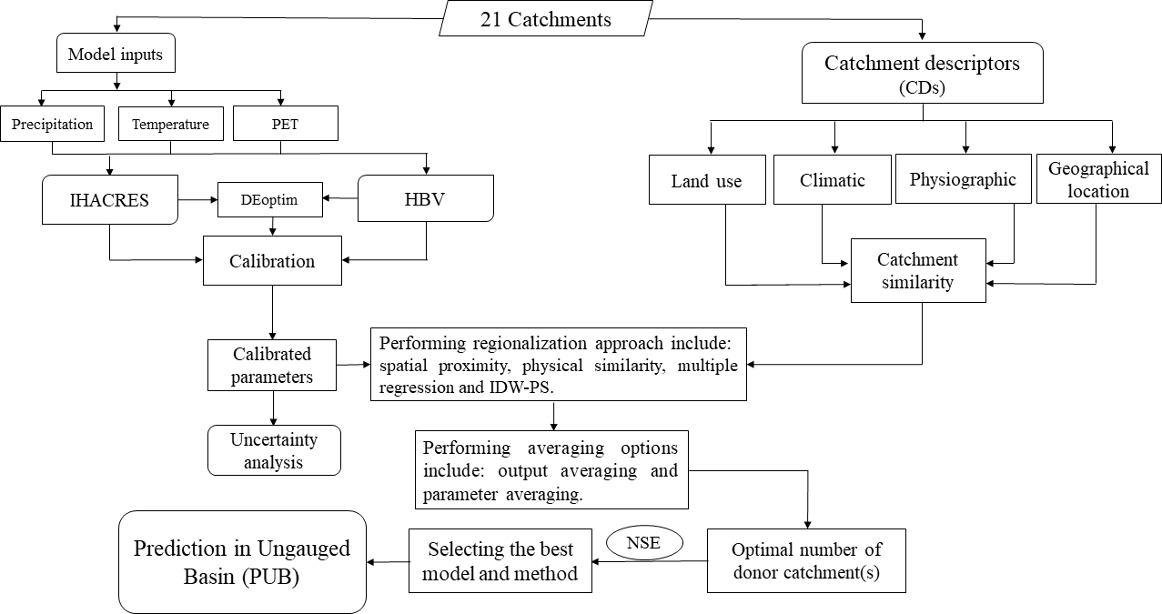
Simulating streamflow in ungauged catchments is a challenge for the management of surface water resources around the world, especially in dry regions. Here, we transfer parameters of two HBV and IHACRES hydrological models from gauged (donor) to ungauged catchments using three main regionalization approaches including Physical Similarity (PS), Multiple Regression (MR), Spatial Proximity (SP) and an integrated approach, which is basically an extension of PS approach through Inverse Distance Weighted (IDW) method (IDW-PS). We use a set of 21 catchments in Hamoun-Jazmourian River Basin in southeast Iran, to compare regionalization approaches. The results indicate that (1) generally, the HBV model performs slightly better than IHACRES model in calibration, verification, and regionalization, (2) the physical similarity method under 2 to 4 donor catchments and multiple regression method provide the best and least satisfactory results respectively. The IDW-PS method improves the performance of IDW method, (3) for the physical similarity, eight Catchment Descriptors (CDs) in four main groups of climate, physiographic, location, and land use perform best in prediction performance, (5) the HBV parameters related to snow and runoff components, are associated with highest and lowest uncertainties respectively. For the IHACRES, the most and least robustness parameters are plant stress threshold factor, f and the proportion of slow flow to total flow, vs respectively. Testing the parameter transferability using main approaches of regionalization at two distinct climate regions located in such an extensive river basin is a novelty. The results suggest that the methodology used in this study is rather suitable to simulate streamflow time series of ungauged catchments in the southeast Iran. However, further research is still needed to use this approach in other river basins of Iran.