Teun van Woerkom

and 3 more

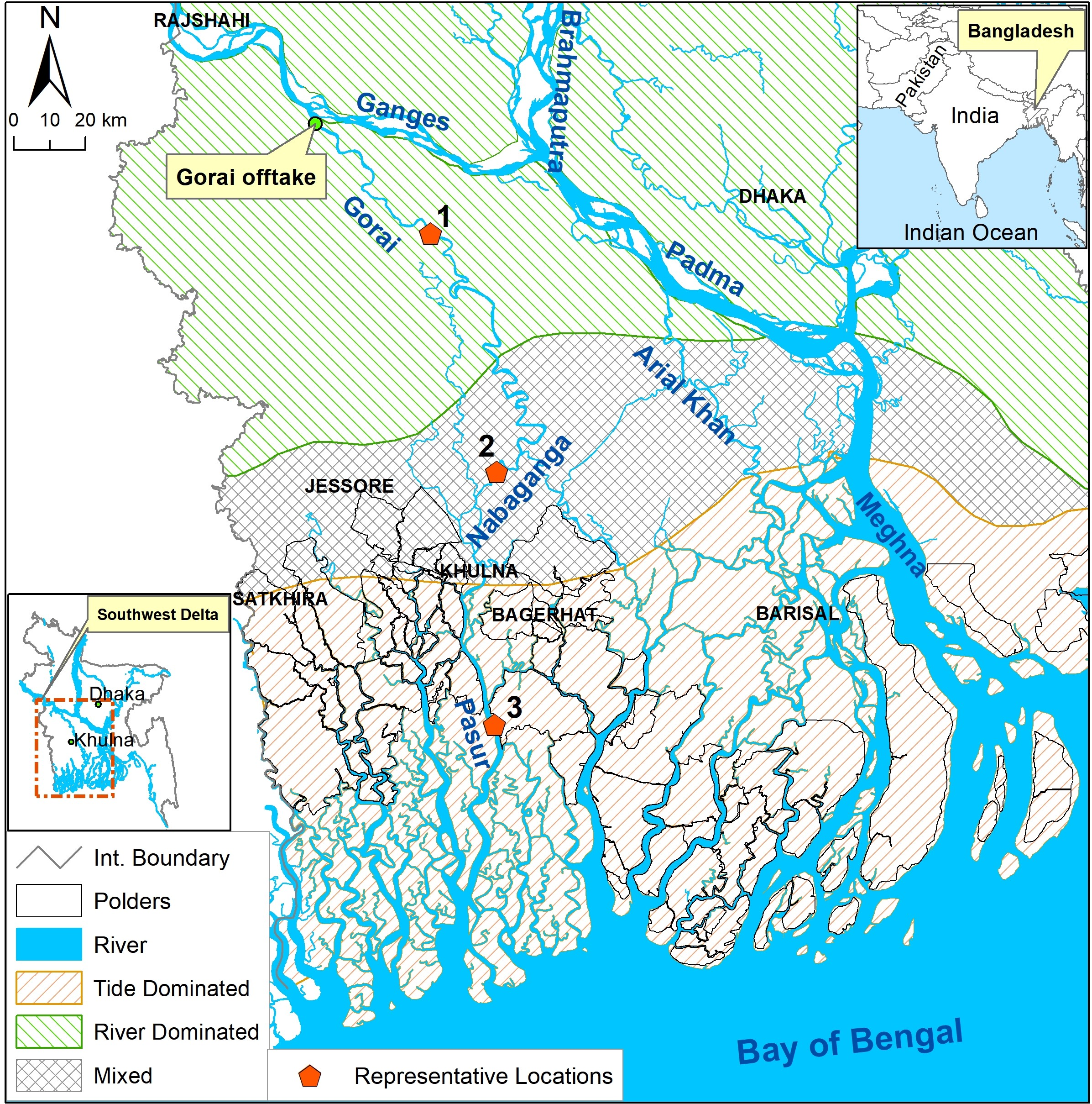
With a large network of dikes that in the future will protect up to 15% of the world’s population from flooding, more extreme river discharges that result from climate change will dramatically increase the flood risk of these protected societies. Precise calculations of dike stability under adverse loading conditions will become increasingly important, though the hydrological impacts on dike stability, particularly the effects of groundwater flow, are often oversimplified in stability calculations. To include these effects, we use a coupled hydro-stability model to indicate relations between the geometry, subsurface materials, groundwater hydrology and stability of a dike regarding soil slip and basal sliding mechanisms. Sensitivity analyses are performed with this model using a large number of parameter combinations, while assessing both the individual sensitivity as combined effects. The analyses show that the material type of the dike and its slope are the more important parameters influencing the stability, followed by the shallow subsurface type and dike crest elevation. The material of the dike and shallow subsurface is additionally important, as a change towards sandier material can either result in either an increase or a decrease of the stability. A database created by an extensive Monte Carlo analysis provides further evidence for these relations and is used to estimate failure probabilities for dike stretches that have not been assessed in detail. Despite the use of a simplified model, not including small-scale heterogeneity, remaining soil strength and transient groundwater flow, the application of the method to a case study proves its applicability.

Md Feroz Islam

and 4 more

The densely populated coastal areas of the Ganges-Brahmaputra-Meghna (GBM) delta within Bangladesh are in danger of losing up to one fourth of their habitable land by 2100 due to relative sea level rise (RSLR). Tidal River Management (TRM) presents an opportunity to combat RSLR by raising the land level through controlled sedimentation in re-opened polder sections. To date, TRM has been applied to tide-dominated coastal regions, but the potential applicability of TRM for river-dominated flow and mixed flow regimes is yet to be assessed. We apply a calibrated 2D numerical hydromorphodynamic model to quantify sediment deposition in a re-opened polder section (‘beel’) under conditions of river-dominated, tide-dominated and mixed flow regimes for different seasons and flow regulations. Simulation results show seasonality in sediment deposition with monsoon season having the highest. The potential for TRM is largest along the reaches of the tide-dominated region where sediment deposition is highest in all three seasons (Pre-monsoon, Monsoon and Dry season), and almost 28 times higher than river-dominated region during monsoon. Regulating flow into a polder increases trapping efficiency, but slightly lower total deposition than without regulation. Our results show that re-establishing polder flooding without regulating the flow into the polder is a promising strategy for the mixed and tide-dominated flow regions in the delta as the sediment deposition can elevate the land more than the yearly rate of RSLR. Application of controlled flooding like TRM therefore provides opportunity to match the rate of RSLR throughout the GBM delta. TRM can potentially be applied to the sinking deltas around the world to counter RSLR.