zhuo Chen

and 4 more

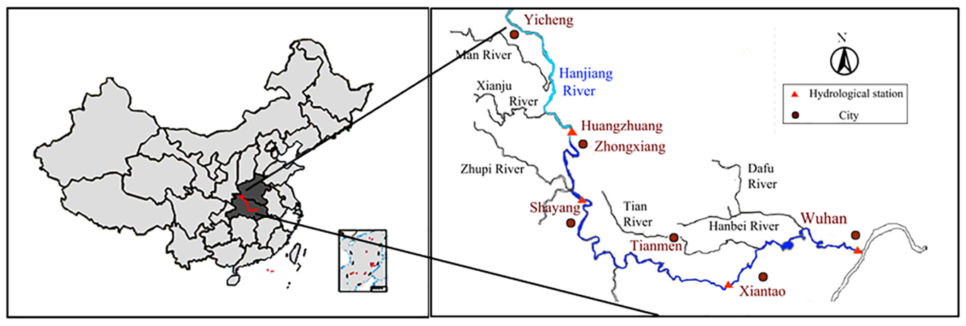
The global construction of water projects has led to a clear trend of river and lake reservoir formation, spurring increasingly serious ecological environmental deterioration, especially that caused by the frequent occurrence of water blooms. Because of monitoring technology limitations, monitoring the algae content index in water has lagged behind the conventional water quality index, which makes sample monitoring too sparse in many rivers and the monitoring data incoherent, so it cannot truly reflect the evolution of water eutrophication. With moderate resolution imaging spectroradiometer (MODIS) remote sensing data monitoring, continuous chlorophyll-a observation data can be collected effectively. This method has important guiding significance for the early warning and control of water blooms. This study considers the middle and lower reaches of the Hanjiang River in China, based on the current remote sensing communication technology, MODIS remote sensing data, and statistical methods and measured chlorophyll-a concentration correlation analysis. Through the use of the trial and error method to establish the band ratio model and BP neural network model, two types of model errors were compared to determine the optimal algorithm settings for the middle and lower reaches of the Hanjiang River chlorophyll-a inversion. Subsequently, the algorithm model for 2000 to 2011 in the middle and lower reaches of the Hanjiang River chlorophyll-a concentration inversion and the results of the inversion analysis of spatiotemporal evolution characteristics we used to determine the influence of various environmental factors on the chlorophyll-a concentration change.

Jinjin Hou

and 4 more

Landslide and debris flows are typically triggered by rainfall-related weather conditions, including short-duration storms and long-lasting rainfall. The critical precipitation of landslide and debris flow occurrence is different under various hydrometeorological conditions. In this study, the daily hydrological states were evaluated by the SWAT model, and the trigger sensitivities of different daily hydrological variables were assessed with 50 days recorded landslide and debris flows between 2010 and 2013. Based on modeled wetness states, the event days were divided into LLR-trigger event days (long-lasting rainfall) and SDS-trigger event days (short-duration storm) with six determinate criteria. The landslide and debris flow prediction model was built using nine hydrometeorological variables and the predictive performance was tested with simulated data from 2010 to 2012. The results suggest that: Historical hydrological variables and their development provide important information for triggering debris flows, though rainfall is the most important factor for triggering debris flows. The landslides and debris flows in the selected subbasins region are triggered on 33 days by LLR and on 17 days by SDS. Specifically, LLR type landslide and debris flow account for a large proportion in July, while SDS type landslide and debris flow occur more frequently in September. The prediction model with the AUC value of 0.85, can capture most of the landslide debris flow. The temporal distribution of the two triggering-event predicted by the model is consistent with the annual distribution of precipitation. Besides, there are spatial variations of the specific trigger types in the different subbasins, which attribute to the different land cover. Despite some uncertainty, this study thereby provides an idea of improving the landslide and debris flow prediction model.