Peggy Bevan

and 6 more

Biogeography has a critical influence on how ecological communities respond to threats and how effective conservation interventions are designed. For example, the resilience of ecological communities is linked to environmental and climatic features, and the nature of threats impacting ecosystems also varies geographically. Understanding community-level threat responses may be most accurate at fine spatial scales, however collecting detailed ecological data at such a high resolution would be prohibitively resource intensive. In this study, we aim to find the spatial scale that could best capture variation in community-level threat responses whilst keeping data collection requirements feasible. Using a database of biodiversity records with extensive global coverage, we modelled species richness and total abundance (the responses) across land-use types (reflecting threats), considering three different spatial scales: biomes, biogeographical realms, and regional biomes (the interaction between realm and biome). We then modelled data from three highly sampled biomes separately to ask how responses to threat differ between regional biomes and taxonomic group. We found strong support for regional biomes in explaining variation in species richness and total abundance compared to biomes or realms alone. Our biome case studies demonstrate that there is a high variation in magnitude and direction of threat responses across both regional biomes and taxonomic group, but all groups in tropical forest showed a consistently negative response, whilst many taxon-regional biome groups showed no clear response to threat in temperate forest and tropical grassland. Our results suggest that the taxon-regional biome unit has potential as a reasonable spatial and ecological scale for understanding how ecological communities respond to threats and designing effective conservation interventions to bend the curve on biodiversity loss.

Mark Miller

and 59 more

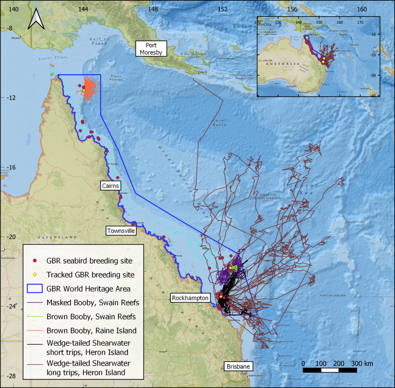
Conservation of breeding seabirds typically requires detailed data on where they feed at sea. Ecological niche models (ENMs) can fill data gaps, but rarely perform well when transferred to new regions. Alternatively, the foraging radius approach simply encircles the sea surrounding a breeding seabird colony (a foraging circle), but overestimates foraging habitat. Here, we investigate whether ENMs can transfer (predict) foraging niches of breeding tropical seabirds between global colonies, and whether ENMs can refine foraging circles. We collate a large global dataset of tropical seabird tracks (12000 trips, 16 species, 60 colonies) to build a comprehensive summary of tropical seabird foraging ranges and to train ENMs. We interrogate ENM transferability and assess the confidence with which unsuitable habitat predicted by ENMs can be excluded from within foraging circles. We apply this refinement framework to the Great Barrier Reef (GBR), Australia to identify a network of candidate marine protected areas (MPAs) for seabirds. We found little ability to generalise and transfer breeding tropical seabird foraging niches across all colonies for any species (mean AUC: 0.56, range 0.4-0.82). Low global transferability was partially explained by colony clusters that predicted well internally but other colony clusters poorly. After refinement with ENMs, foraging circles still contained 89% of known foraging areas from tracking data, providing confidence that important foraging habitat was not erroneously excluded by greater refinement from high transferability ENMs nor minor refinement from low transferability ENMs. Foraging radii estimated the total foraging area of the GBR breeding seabird community as 2,941,000 km2, which was refined by excluding between 197,000 km2 and 1,826,000 km2 of unsuitable foraging habitat. ENMs trained on local GBR tracking achieved superior refinement over globally trained models, demonstrating the value of local tracking. Our framework demonstrates an effective method to delineate candidate MPAs for breeding seabirds in data-poor regions.

Jamie Darby

and 10 more

Animal-borne telemetry devices provide essential insights into the life-history strategies of far-ranging species and allow us to understand how they interact with their environment. Many species in the seabird family Alcidae undergo a synchronous moult of all primary flight feathers during the non-breeding season, making them flightless and more susceptible to environmental stressors, including severe storms and prey shortages. However, the timing and location of moult remains largely unknown, with most information coming from studies on birds killed by storms or shot at sea. Using light-level geolocators with saltwater immersion loggers, we develop a method for determining flightless periods in the context of the annual cycle. Four Atlantic puffins (Fratercula arctica) were equipped with geolocator/immersion loggers on each leg to attempt to overcome issues of leg-tucking in plumage while sitting on the water, which confounds the interpretation of logger data. Light level and saltwater immersion time-series data were combined to correct for this issue. This approach was adapted and applied to 40 puffins equipped with the standard practice deployments of geolocators on one leg only. Flightless periods consistent with moult were identified in the dual-equipped birds, whereas moult identification in single-equipped birds was less definitive and should be treated with caution. Within the dual-equipped sample, we present evidence for two flightless moult periods per non-breeding season in two puffins that undertook more extensive migrations (> 2000km), and were flightless for up to 76 days in a single non-breeding season. A biannual flight feather moult is highly unusual among non-passerine birds, and may be unique to birds that undergo catastrophic moult, i.e. become flightless when moulting. Though our conclusions are based on a small sample, we have established a freely available methodological framework for future investigation of the moult patterns of this and other seabird species.