Liuwei Xu

and 6 more

We image the rupture process of the 2021 Mw 7.4 Maduo, Tibet earthquake using slowness-enhanced back-projection and joint finite fault inversion, which combines teleseismic broadband body waves, long-period (166-333 s) seismic waves, and 3D ground displacements from radar satellites. The results reveal a left-lateral strike-slip rupture, propagating bilaterally on a 160-km-long north-dipping sub-vertical fault system that bifurcates near its east end. About 80% of the total seismic moment occurs on the asperities shallower than 10 km, with a peak slip of 5.7 m. To simultaneously match the observed long-period seismic waves and static displacements, notable deep slip is required, despite a tradeoff with the rigidity of the shallow crust. This coseismic deep slip within the ductile middle crust could result from strain localization and dynamic weakening. Local crustal structure and synthetic long-period Earth response for Tibet earthquakes thus deserve further investigation. The WNW branch ruptures ~75 km at ~2.7 km/s, while the ESE branch ruptures ~85 km at ~3 km/s, though super-shear rupture propagation possibly occurs during the ESE propagation from 12 s to 20 s. Synthetic back-projection tests confirm overall sub-shear rupture speeds and reveal a previously undocumented limitation caused by the signal interference between two bilateral branches. The stress analysis on the forks of the fault demonstrates that the pre-compression inclination, rupture speed, and branching angle could explain the branching behavior on the eastern fork.
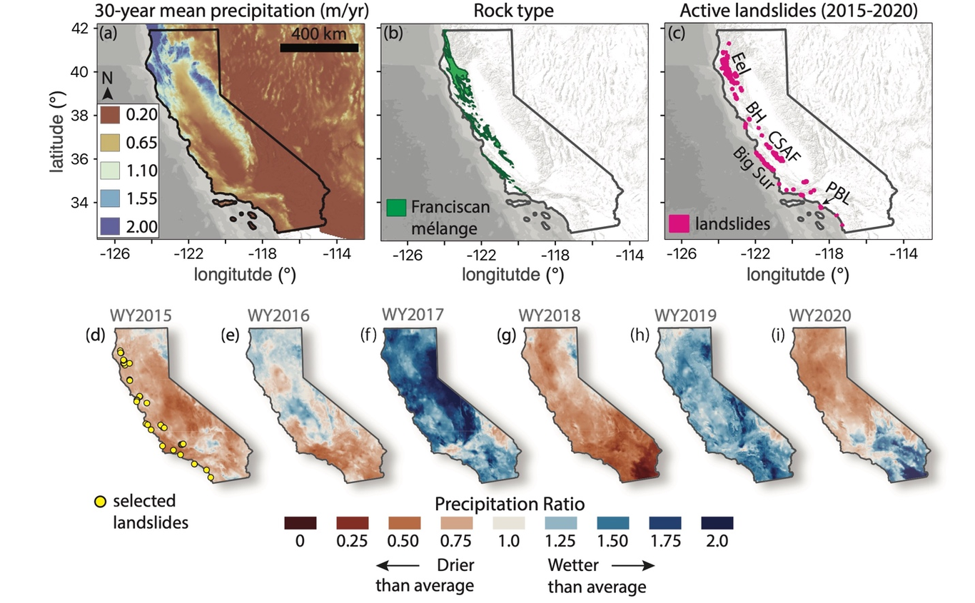
The hazardous impact and erosive potential of slow-moving landslides depends on landslide properties including velocity, size, and frequency of occurrence. However, constraints on size, in particular, subsurface geometry, are lacking because these types of landslides rarely fully evacuate material to create measurable hillslope scars. Here we use pixel offset tracking with data from the NASA/JPL Uninhabited Aerial Vehicle Synthetic Aperture Radar (UAVSAR) to measure the three-dimensional surface deformation of 134 slow-moving landslides in the northern California Coast Ranges. We apply volume conservation to infer the actively deforming thickness, volume, geometric scaling, and frictional strength of each landslide. These landslides move at average rates between ~0.1–3 m/yr and have areas of ~6.1 x 10^3–2.35 x 10^6 m^2, inferred mean thicknesses of ~1.1–25 m, and volumes of ~7.01 x 10³–9.75 x 10^6 m^3. The best-fit volume-area geometric scaling exponent is γ ~ 1.2–1.5, indicating that these landslides fall between typical soil and bedrock landslide scaling. A rollover in the scaling relationship suggests that the largest landslide complexes in our dataset become large primarily by increasing in area rather than thickness. In addition, the slow-moving landslides display scale-dependent frictional strength, such that large landslide tend to be weaker than small landslides. This decrease in frictional strength with landslide size is likely because larger landslides are composed of higher proportions of weak material. Our work shows how state-of-the-art remote sensing techniques can be used to better understand landslide processes and quantify their contribution to landscape evolution and hazards to human safety.

Eric Fielding

and 7 more

The subduction zone of the Cocos Plate beneath Southern Mexico has major variations in the megathrust geometry and behavior. The subduction segment beneath the Oaxaca state of Mexico has relatively frequent large earthquakes on the shallow part of the megathrust and within the subducting slab, and it also has large aseismic slow-slip events. The slab geometry under Oaxaca includes part of the subhorizontal “flat-slab” zone extending far from the trench beneath southern Mexico and the beginning of its transition to more regular subduction geometry to the southeast. We study the rupture of the 16 February 2018 Mw 7.2 Pinotepa earthquake near Pinotepa Nacional in Oaxaca that was a thrust event on the subduction interface. The Pinotepa earthquake was about 350 km away from the 8 September 2017 Mw 8.2 Tehuantepec earthquake in the subducting slab offshore Oaxaca and Chiapas; it was in an area of Coulomb stress decrease from the M8.2 quake, so it seems unlikely to be a regular aftershock and was not triggered by the static stress change. Geodetic measurements from interferometric analysis of synthetic aperture radar (InSAR) and time-series analysis of GPS station data constrain finite-fault slip models for the M7.2 Pinotepa earthquake. We analyzed InSAR data from Copernicus Sentinel-1A and -1B satellites and JAXA ALOS-2 satellite. Our Bayesian (AlTar) static slip model for the Pinotepa earthquake shows all of the slip confined to a very small (10-20 km diameter) rupture, similar to some early seismic waveform fits. The Pinotepa earthquake ruptured a portion of the Cocos megathrust that has been previously mapped as partially coupled and shows that at least small asperities in that zone of the subduction interface are fully coupled and fail in high-stress drop earthquakes. The previous 2012 Mw 7.4 Ometepec earthquake is another example of asperity in the partially coupled zone but was not imaged by InSAR so the rupture extent is not so well constrained. The preliminary NEIC epicenter for the Pinotepa earthquake was about 40 km away (NE) from the rupture imaged by InSAR, but the NEIC updated epicenter and Mexican SSN location are closer. Preliminary analysis of GPS data after the Pinotepa earthquake indicates rapid afterslip on the megathrust in the region of coseismic slip. Atmospheric noise masks the postseismic signal on early InSAR data.

Uri S ten Brink

and 7 more

Eric Fielding

and 9 more

The 4 July 2019 Mw 6.4 Earthquake and 5 July Mw 7.1 Earthquake struck near Ridgecrest, California. Caltech-Jet Propulsion Laboratory Advanced Rapid Imaging and Analysis (ARIA) project automatically processed synthetic aperture radar (SAR) images from Copernicus Sentinel-1A and -1B satellites operated by the European Space Agency, and products were delivered to the US and California Geological Surveys to aid field response. We integrate geodetic measurements for the three-dimensional vector field of coseismic surface deformation for thee two events and measure the early postseismic deformation, using SAR data from Sentinel-1 satellites and the Advanced Land Observation Satellite-2 (ALOS-2) satellite operated by Japanese Aerospace Exploration Agency. We combine less precise large-scale displacements from SAR images by pixel offset tracking or matching, including the along-track component, with the more precise SAR interferometry (InSAR) measurements in the radar line-of-sight direction and intermediate-precision along-track InSAR to estimate all three components of the surface displacement for the two events together. InSAR coherence and coherence change maps the surface disruptions due to fault ruptures reaching the surface. Large slip in the Mw 6.4 earthquake was on a NE-striking fault that intersects with the NW-striking fault that was the main rupture in the Mw 7.1 earthquake. The main fault bifurcates towards the southeast ending 3 km from the Garlock Fault. The Garlock fault had triggered slip of about 15 mm along a short section directly south of the main rupture. About 3 km NW of the Mw 7.1 epicenter, the surface fault separates into two strands that form a pull-apart with about 1 meter of down-drop. Further NW is a wide zone of complex deformation. We image postseismic deformation with InSAR data and point measurements from new GPS stations installed by the USGS. Initial analysis of the first InSAR measurements indicates the pull-apart started rebounding in the first weeks and the main fault had substantial afterslip close to the epicenter where the largest coseismic slip occurred. Slip on a NE-striking fault near the northern end of the main rupture in the first weeks, in the same zone as large and numerous aftershocks along NE-striking and NW-striking trends shows complex deformation.

Jeanne Sauber

and 5 more

Of the major coastal land change mechanisms responsible for relative sea-level change, tectonic subsidence is generally quoted as ranging from < mm/yr to 1 cm/yr. However, we documented coseismic and ongoing post-earthquake surface displacements from continuous GPS and tide gauge/altimetry data that indicated rapid subsidence on two of the major Samoan Islands of 12 - 20 cm during and following the 8.1 2009 Tonga-Samoa earthquake. Earlier results and our modeling of GRACE-derived gravimetric data provided a preliminary forecast of future relative sea-level rise through rapid land subsidence [Han et al., 2019]. Of course these numerical forecasts of time-dependent deformation are only as good as our input observations and our assumed rheological models. As part of our current NASA Earth Surface and Interior study, we are obtaining a wider range of data to constrain and test alternate models of ongoing postseismic deformation across American Samoa and Upolu, Samoa: (1) times series of altimetry plus tide gauge data processed to complement the cGPS data available to provide high-temporal resolution, point measurements of uplift/subsidence, (2) InSAR derived observations of surface deformation across the highly vegetated Samoan Islands, (3) evaluating and using NASA satellite lidar data (ICESat-I & ICESat-II, GEDI) for fusion with multi-source topographic data sets and for estimating topographic change on the decadal time scale. We are evaluating and using these new observations to better understand and separate out local, island-wide, and multi-island subsidence patterns and to evaluate the high impact of rising sea-level in a tectonically active region.