Zhenqi Shi

and 3 more

全球范围内,土壤盐碱化加剧,碱化并存。特别是,沿海生态系统由于其形成过程和地理位置而更容易受到盐分问题的影响。沿海生态系统的氮(N)循环过程与盐碱变化有关。农业生态系统中的氨(NH 3)挥发是氮损失的最重要途径之一,也被认为是沿海生态系统空气污染的主要贡献者。作为地球上最容易获得的土地资源,阐明和量化盐碱对 N 含量和 NH 3的影响沿海生态系统的挥发对于提高沿海农业生产力至关重要。证明效果的挑战是如何确定盐碱的直接影响以及这两个因素如何 通过相互作用间接影响 NH 3挥发。通过将孵化实验与结构方程建模方法(SEM“元素”模型)相结合,我们揭示了盐碱对NH 3挥发的净影响以及环境因素在相互作用网络中的作用。与CK处理相比,NH 3在尿素添加量0.05‰、0.10‰、0.15‰时,随着盐度梯度从1‰增加到15‰,挥发度分别增加了9.31-34.98%、3.07-26.92%和2.99-43.61%。随着碱度从0.5‰增加到8‰,NH 3的挥发量分别显着增加8.36-56.46%、5.49-30.10%和30.72-73.18%。根据元素模型,盐和碱既直接促进NH 3挥发,又通过改变微生物的N含量和N转化产生间接的负面影响。培养体系中N含量对NH 3挥发有直接的正向影响,在盐度和碱度升高时降低明显。此外,N转化微生物的基因丰度增强了NH 3间接挥发。盐碱对NH 3挥发的间接抑制作用被对pH和NH 4 +含量的直接刺激作用所补偿,盐的整体正贡献小于碱。我们的研究结果表明,伴随的土壤碱化可以提高沿海盐碱区的 NH 3排放潜力。

Xiang Zhang

and 2 more

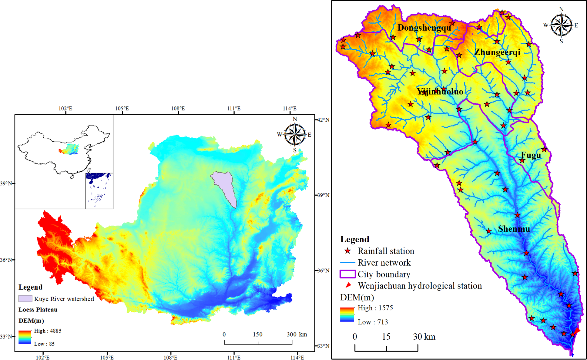
Soil and water conservation measures, especially reforestation and check dam construction, have been progressively implemented on the coarse sandy hilly catchment region of the Yellow River basin for several decades, and climate conditions are also dynamic. Therefore, it is very urgent to understand how the precipitation variation, land use changes and check dams affect soil erosion and sediment yield in a large watershed. The sediment delivery distributed (SEDD) model was employed to quantitatively identify the impacts of the three factors on soil erosion and sediment yield in the Kuye River watershed. Significant land use changes, with the conversion of arable land and bare land to vegetation cover and construction land, occurred in the study watershed from 1987 to 2016. In addition, 306 key dams were built in the watershed, with a total storage capacity of 316.64 Mm3, according to the statistical data of 2011. Hot spot analysis showed that the high-risk regions for soil erosion and sediment yield were mainly concentrated in the middle reaches of the watershed. The simulation results showed that the check dams were the dominant factor, reducing total sediment load by 53.77% in 2006. However, from 1987 to 2016, the contribution of these three factors (precipitation variation, land use changes and check dams) to sediment reduction was 29.10%, 40.09% and 30.81%, respectively, which indicated that all of them had significant influence on sediment load. The results can serve as a reference for watershed management and policy implementation.

Xiang Zhang

and 3 more

Reforestation and check dam construction have been progressively implemented on the Loess Plateau for several decades. However, it is still unclear how the two major sediment control strategies affect soil erosion and sediment yield in a large watershed. A combination of field investigation and model simulation was employed to quantitatively identify the impacts of the two measures on soil erosion and sediment yield in the Kuye River watershed. Significant land use changes, with the conversion of arable land and bare land to vegetation cover and construction land, occurred in the study watershed from 1987 to 2016. In addition, 306 key dams were built in the watershed, with a total storage capacity of 316.64 Mm3, according to the statistical data of 2011. Hot spot analysis showed that the high-risk regions for soil erosion and sediment yield were mainly concentrated on the periphery of Shenmu County and the outlet of the watershed. The simulation results showed that the land use changes from 1987 to 2016 remarkably reduced sediment yield by 51.14% without considering the action of check dams. In the 1987 scenario, the sediment yield was reduced by 50.44% when considering the action of check dams compared with the yield that was estimated without consideration of check dams. Under the combined effect of the two factors, the sediment yield decreased by 73.91% in 2016. More attention should be paid to check dams, and corresponding measures should be taken to protect them, especially in the flood period.