I.P. Senanayake

and 5 more

High spatial resolution soil moisture information is important for regional–scale hydrologic, climatic and agricultural applications. However, available point-scale in-situ measurements and coarse-scale (~10s of km) satellite soil moisture retrievals are unable to capture hillslope to sub-catchment level spatial variability of soil moisture as required by many of these applications. Downscaling L-band satellite soil moisture retrievals appears to be a viable technique in estimating near surface (~ top 5 cm) soil moisture at a high spatial resolution. Among different downscaling approaches, thermal data based methods exhibits a good potential over arid and semi-arid regions, i.e. in many parts of Australia. This study investigates three downscaling approaches based on soil thermal inertia to estimate near surface soil moisture at high spatial resolution (1 km) over Krui and Merriwa River catchments in the Upper Hunter region of New South Wales, Australia. These methods are based upon the relationship between the diurnal soil temperature difference (ΔT) and daily mean soil moisture content (μSM). Regression tree models between ΔT and μSM were developed by using in-situ observations (in the first approach) and using land surface model (LSM) based estimates (in the second approach). The relationship between ΔT and μSM was modulated by the vegetation density and the Austral season. In the in-situ data based approach, soil texture was also employed as a modulating factor. These in-situ datasets were obtained from the Scaling and Assimilation of Soil Moisture and Streamflow (SASMAS) network and model-based estimates from the Global Land Data Assimilation System (GLDAS). Moderate Resolution Imaging Spectroradiometer (MODIS) derived Normalized Difference Vegetation Index (NDVI) products were used to define vegetation density. An ensemble machine-learning model was employed in the third approach using ΔT, NDVI and Austral season as predictors and μsm values as responses. Aggregated airborne soil moisture retrievals were used as the coarse resolution soil moisture products. These coarse resolution soil moisture simulations were downscaled to 1 km by employing the above three approaches using MODIS-derived ΔT and NDVI values. The results from the three downscaling methods were compared against the 1 km soil moisture retrievals from the National Airborne Field Experiment 2005 (NAFE’05) over 3 days in November 2005. The results from both in-situ data and GLDAS-based regression tree models show RMSEs of 0.07 cm3/cm3 when compared against the high resolution NAFE’05 airborne soil moisture observations. The GLDAS-based model can be applied over a larger extent, whereas the in-situ data based model is catchment specific. These results were compared with the results from the machine-learnt model. A combination of these methods with additional forcing factors such as topography, meteorology, etc. can be utilized to develop an improved downscaling model. Such a mod

I.P. Senanayake

and 7 more

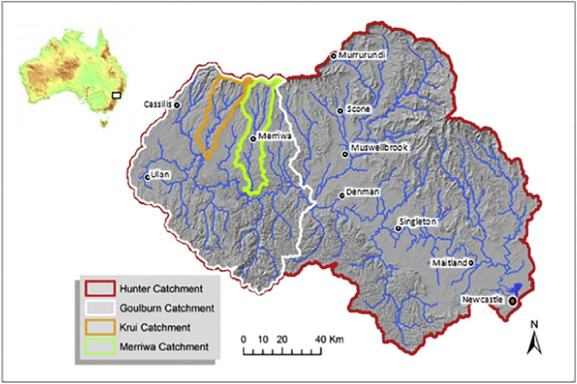
Long-term soil moisture datasets at high spatial resolution are important in agricultural, hydrological, and climatic applications. The soil moisture estimates can be achieved using satellite remote sensing observations. However, the satellite soil moisture data are typically available at coarse spatial resolutions (~ several tens of km), therefore require further downscaling. Different satellite soil moisture products have to be conjointly employed in developing a consistent time-series of high resolution soil moisture, while the discrepancies amongst different satellite retrievals need to be resolved. This study aims to downscale three different satellite soil moisture products, the Soil Moisture and Ocean Salinity (SMOS, 25 km), the Soil Moisture Active Passive (SMAP, 36 km) and the SMAP-Enhanced (9 km), and to conduct an inter-comparison of the downscaled results. The downscaling approach is developed based on the relationship between the diurnal temperature difference and the daily mean soil moisture content. The approach is applied to two sub-catchments (Krui and Merriwa River) of the Goulburn River catchment in the Upper Hunter region (NSW, Australia) to estimate soil moisture at 1 km resolution for 2015. The three coarse spatial resolution soil moisture products and their downscaled results will be validated with the in-situ observations obtained from the Scaling and Assimilation of Soil Moisture and Streamflow (SASMAS) network. The spatial and temporal patterns of the downscaled results will also be analysed. This study will provide the necessary insights for data selection and bias corrections to maintain the consistency of a long-term high resolution soil moisture dataset. The results will assist in developing a time-series of high resolution soil moisture data over the south-eastern Australia.

David Bretreger

and 7 more

The measurement of soil moisture can be a time-consuming task that can be difficult to capture spatially and temporally. The accuracy of soil moisture measurements is essential to improve aspects of hydrology in a range of modelling situations. This paper compares soil moisture measurements from two un-calibrated in-situ measurement devices against gravimetric data. The devices used are a Delta T Theta Probe and a Campbell Scientific CS659 while the gravimetric readings are from soil cores (12 cm and 21 cm). The soil moisture readings were taken over two large semi-arid catchments (562 km2 and 808 km2) located in South East Australia in the Hunter Valley, NSW. Multiple field campaigns were conducted in 2014, 2015 and 2018, resulting in 308 gravimetric samples for analysis in predominately clay soils. The two core depths sampled showed a strong correlation coefficient (R value) of 0.89. The gravimetric and probe measurements returned R values of approximately 0.8 for 2014 and 2015. The 2018 results showed a decrease in correlation (to approximately 0.3 and 0.5) although this coincided with average gravimetric soil moisture values being much lower than previous data collection campaigns (approximately 13% opposed to 20-23%). The extreme dry period potentially the reason for the reduced correlation. The manufacturer calibrated probe measurements did not provide a 1:1 relationship with the lab based gravimetric soil moisture. Results show that either the Theta Probe or CS659 are comparable to the gravimetric results in most conditions. Both the Theta Probe and CS659 regressions produced root mean square errors that were within the quoted accuracy in the device manuals, ±5% and ±3% respectively. The instruments may be used in conditions showing soil moistures of ~5% to ~45%, although the best results will be obtained by using appropriate techniques and knowing the potential limitations of devices. The linear regression equations found in this study may also allow calibration of probes for future measurements.