Fen Zhao

and 9 more

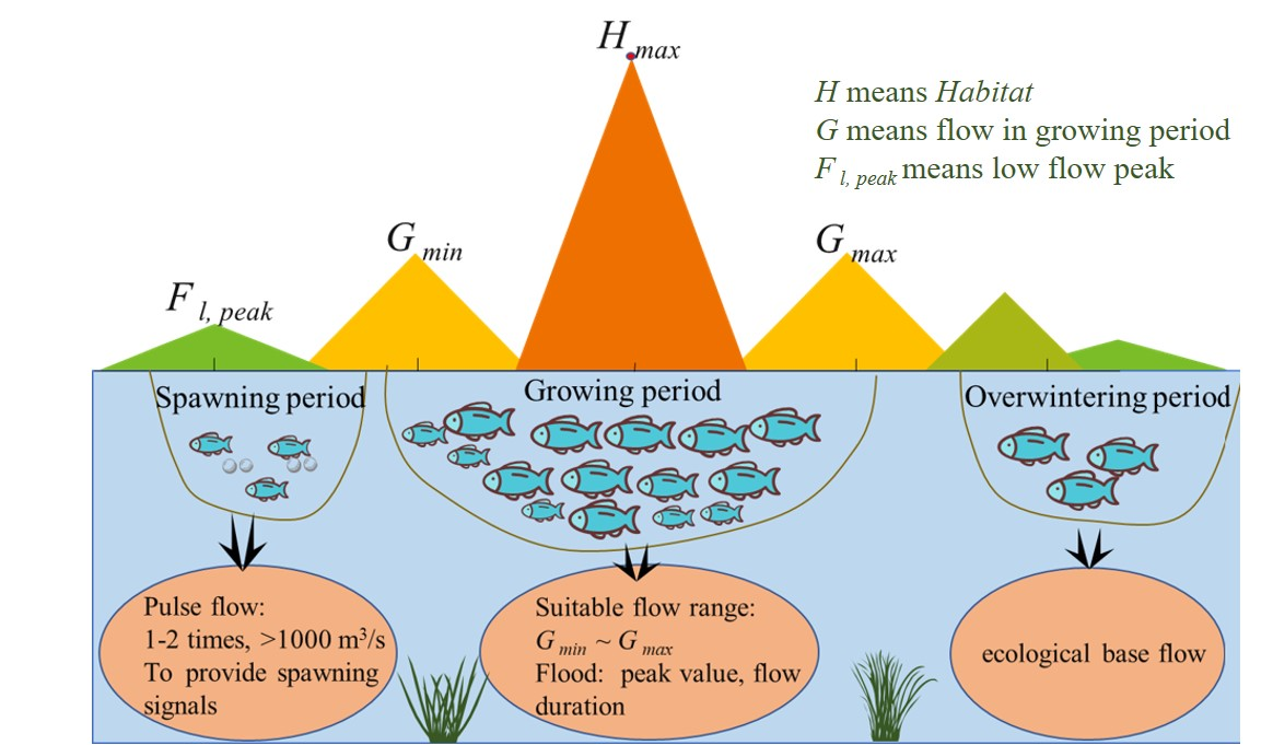
The Yellow River Basin is of great significance to China’s economic and social development and ecological security. The Yellow River Basin is not only an important ecological barrier but also an important economic zone. In this paper, natural hydrological conditions were taken as a reference, a habitat simulation model of the key sections of the Yellow River was constructed based on the MIKE 21 model, and an ecological water requirement assessment method for river ecological integrity combined with habitat simulation and features of the hydrological reference group was established, which takes into account the survival and reproduction of indicator species. The suitable flow rates for the spawning period of Silurus lanzhouensis in Lanzhou and Xiaheyan and Cyprinus carpio in Toudaoguai, Longmen and Huayuankou were 350-720 m3/s, 350-600 m3/s, 150-500 m³/s, 260-400 m3/s, and 100-500 m³/s, respectively. Therefore, high pulse flow with a low flow peak should be guaranteed in mid- to late April. The peak flow should be at least approximately 1,000 m3/s to ensure that fish receive spawning signals, with a high pulse flow process occurring 1-2 times in May to June. The annual ecological water requirement of the Lanzhou, Xiaheyan, Toudaoguai, Longmen and Huayuankou sections was 9.1-11 ×109 m³, 6.3-10.4×10⁹ m³, 3.8-8.2×10⁹ m³, 4.7-11.3×10⁹ m³ and 7.9-15.4×10⁹ m³, respectively. The model quantitatively simulates the changes in ecological water requirement of indicator fishes in key sections of the Yellow River, and an effective and more realistic tool for ecological water requirement accounting of the Yellow River has been provided.

Yujun Yi

and 2 more

Dams are built on rivers to make effective use of, inter alia, water resources, flood protection, and power generation. The construction of dams has greatly promoted the economy and social development, but also reduced the connectivity of rivers, which leads to the weakening of the exchange of material and biological organisms between rivers. The connectivity of rivers directly determines the self-purification and pollution capacity of water bodies, and the migration possibility of fish, which are all important indexes for quantifying the ecological health in basins. In this study, the connectivity of the two largest river basins in China, the Yangtze River and Yellow River Basins, was investigated. The Dendritic Connectivity Index (DCI) was applied to evaluate the impact on river connectivity of dams with a reservoir capacity of larger than 100 million m3. The results show that river connectivity decreased as dam construction increased. The connectivity of the Yangtze River Basin was good in the 1980s, but declined significantly after the Gezhouba Dam was constructed on the mainstream. The changes in the connectivity indexes of potadromous fish (DCIp) and diadromous fish (DCId) were determined for the period of 1980–2010. In the Yangtze River Basin, the DCIp decreased by 58% (from 81.25 to 34.16) and the DCId decreased by 53% (from 89.98 to 42.30). In the Yellow River Basin, the DCIp decreased by 38% (from 51.46 to 31.81) and the DCId decreased by 60% (from 32.74 to 13.00). In both basins, dams on the mainstream are the main cause of the decline in the DCI, dams located on the middle reaches are the main cause of the decline in the DCIp, and dams located on the lower reaches close to the estuary are the main cause of the decline in the DCId.