Haitao Tian

and 9 more

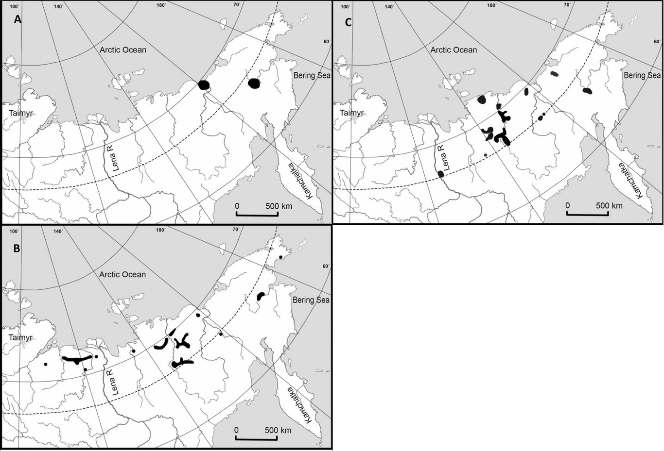
The Lesser White-fronted Goose (Anser erythropus), smallest of the “grey” geese, is listed as Vulnerable on the IUCN Red List and protected in all range states. There are three sub-populations, with the least studied being the East Asian sub-population, shared between Russia and China. The extreme remoteness of breeding enclaves makes them largely inaccessible to researchers. As a substitute for visitation, remotely tracking birds from wintering grounds allows exploration of their summer range. Over a period of three years, and using highly accurate GPS tracking devices, eleven individuals of A. erythropus were tracked from the key wintering site of Dongting Lake, China, to breeding, molting, and staging sites in north-eastern Russia. Data obtained from that tracking, bolstered by ground survey and literature records, were used to model the summer distribution of A. erythropus. Although earlier literature suggests the summer range is patchy, the model confirms a contiguous summer range. The most suitable habitats are located along the coasts of the Laptev Sea, primarily the Lena-Delta, in the Yana-Kolyma Lowland, and smaller lowlands of Chukotka with narrow riparian extensions upstream along major rivers such as the Lena, Indigirka and Kolyma. The probability of A. erythropus presence is related to sites with altitude less than 500 m with abundant wetlands, especially riparian habitat, and a climate with precipitation of warmest quarter around 55 mm and mean temperature of wettest quarter around 14oC. Human disturbance also affects site suitability, with a gradual decrease in species presence starting around 160 km from human settlements. Remote tracking of animal species can bridge the knowledge gap required for robust estimation of species distribution patterns in remote areas. Better knowledge of species’ distribution is important in understanding the large-scale ecological consequences of rapid global change and establishing conservation management strategies.

Yamian Zhang

and 6 more

Geographical gradients in species diversity have long fascinated biogeographers and ecologists. However, the extent and generality of the positive/negative effects of the important factors governing functional diversity (FD) patterns are still debated, especially for the freshwater domain. We examined lake productivity and functional richness (FRic) of waterbirds sampled from 35 lakes and reservoirs in northern China with a geographic coverage of over 5 million km2. We used structural equation modelling (SEM) to explore the causal relationships between geographic position, climate, lake productivity and waterbirds FRic. We found unambiguous altitudinal and longitudinal gradients in lake productivity and waterbirds FD, which were strongly mediated by local environmental factors. Specifically, we found 1) lake productivity increased northeast but decreased with altitude, and the observed gradients were driven by climate and nutrient availability, with 93% of variation explained in the individual SEM; 2) waterbirds FD showed similar geographic and elevational gradients.; the environmental factors which had direct and/or indirect effects on these geographic and elevational gradients included climate, lake productivity and morphology, which collectively explained more than 56% of the variation in waterbirds FD; and 3) a significant (P = 0.029) causality between lake productivity and waterbirds FD was confirmed. Nevertheless, the causality link was relatively weak in comparison with climate and lake area (standardized path coefficient was 0.65, 0.21, and 0.17 for climate, area, and productivity, respectively). Through articulating the dominant causality paths, our results could contribute to the mechanistic explanations underlying the observed broad–scale biodiversity gradients.

Bin Li

and 5 more

Habitat degradation is expected to alter community structure and consequently, ecosystem functions including the maintenance of biodiversity. Understanding the underlying abiotic and biotic assembly mechanisms controlling temporal and spatial community structure and patterns is a central issue in biodiversity conservation. In this study, using monthly time series of benthic fish data collected over a three-year period, we compared the temporal community dynamics in natural and modified habitats in one of the largest river-lake floodplain ecosystems in China, the Dongting Lake. We found a prevailing strong positive species covariance, i.e. species abundance changes in the same way, in all communities that was significantly negatively impacted by water nutrients levels. The positive species covariance, which was consistent for both wet and dry years and among habitat types, had significantly negative effects on community stability, which was measured by the average of aggregated abundance divided by temporal standard deviation. In contrast to species covariance, community stability was significantly higher in modified habitats than in natural habitats. Furthermore, our results demonstrated that the ecological stochasticity (i.e. community assembly processes generating diversity patterns that are indistinguishable from random chance) was significantly higher at natural sites than at the modified sites, suggesting that deterministic processes might control the community composition (richness and abundance) at the modified habitat through reducing species synchrony and positive species covariance observed in the natural habitats. When combined, our results suggest that human habitat modification creates environmental conditions for the development of stable benthic fish community in the highly dynamic floodplains, leading to niche-based community and decrease of temporal β-diversity.