Alfonso Senatore

and 7 more

This study investigates the spatial and temporal dynamics of DOC concentration in a Mediterranean headwater catchment (Turbolo River catchment, southern Italy) equipped with two multi-parameter sondes providing more than two-year (May 2019 to November 2021) continuous high-frequency measurements of several DOC-related parameters. The sondes were installed in two nested sections, a quasi-pristine upstream sub-catchment and a downstream outlet with some anthropogenic disturbances on water quality. DOC estimates were achieved by correcting the fluorescent dissolved organic matter - fDOM - values through an original procedure not requiring extensive laboratory measurements. Then, DOC dynamics at the seasonal and storm event scales were analyzed. At the seasonal scale, results confirmed the climate control on DOC production, with increasing background concentrations in hot and dry summer months. The hydrological regulation proved crucial for DOC mobilization and export, with the top 10th percentile of discharge associated with up to 79% of the total DOC yield. The analysis at the storm scale using flushing and hysteresis indices highlighted substantial differences between the two catchments. In the steeper upstream catchment, the limited capability of preserving hydraulic connection in time with DOC sources determined the prevalence of transport as the limiting factor to DOC export. Downstream, transport- and source-limited processes were observed almost equally. The correlation between the hysteretic behaviour and antecedent precipitation was not linear since the process reverted to transport-limited for high accumulated rainfall values. The study demonstrated the importance of high-resolution measurements to explain DOC dynamics at multiple time scales using a quantitative approach.

Alfonso Senatore

and 5 more

Enhancing an understanding of expansion/contraction dynamics of active drainage networks is fundamental for both scientific purposes and environmental planning and management. This study analyzes for the first time the network shrinking and dry down in two seasonally dry Mediterranean catchments (overall area 1.15 km2) using a comprehensive approach based on monitoring and modeling of the active network. A seasonal field campaign consisting of 19 subweekly visual surveys was carried out at the beginning of the summer of 2019. Observations were then used to calibrate and validate an integrated model aimed at estimating the time evolution of the total active drainage network length based on meteorological drivers and defining the position of the active stretches based on topographic and geological information. Statistical modeling of the active length showed that weather can successfully describe the observed variability of network dynamics during the summer recession. In particular, the study emphasizes the role of evapotranspiration in the seasonal contraction of the stream network. The modeling of the spatial patterns of the active network achieved good performance when topographic data were used as explanatory variables. Nevertheless, the model performance further increased when site-specific geological information was integrated into the model, with accuracies higher than 90% in cell-by-cell comparisons. The proposed methodology, which combines meteorological, topographic and geological information in a sequential manner, was able to accurately represent the space/time dynamics of the active drainage network in the study area, proving to be an effective and flexible tool for the study of network dynamics.

Luca Furnari

and 3 more

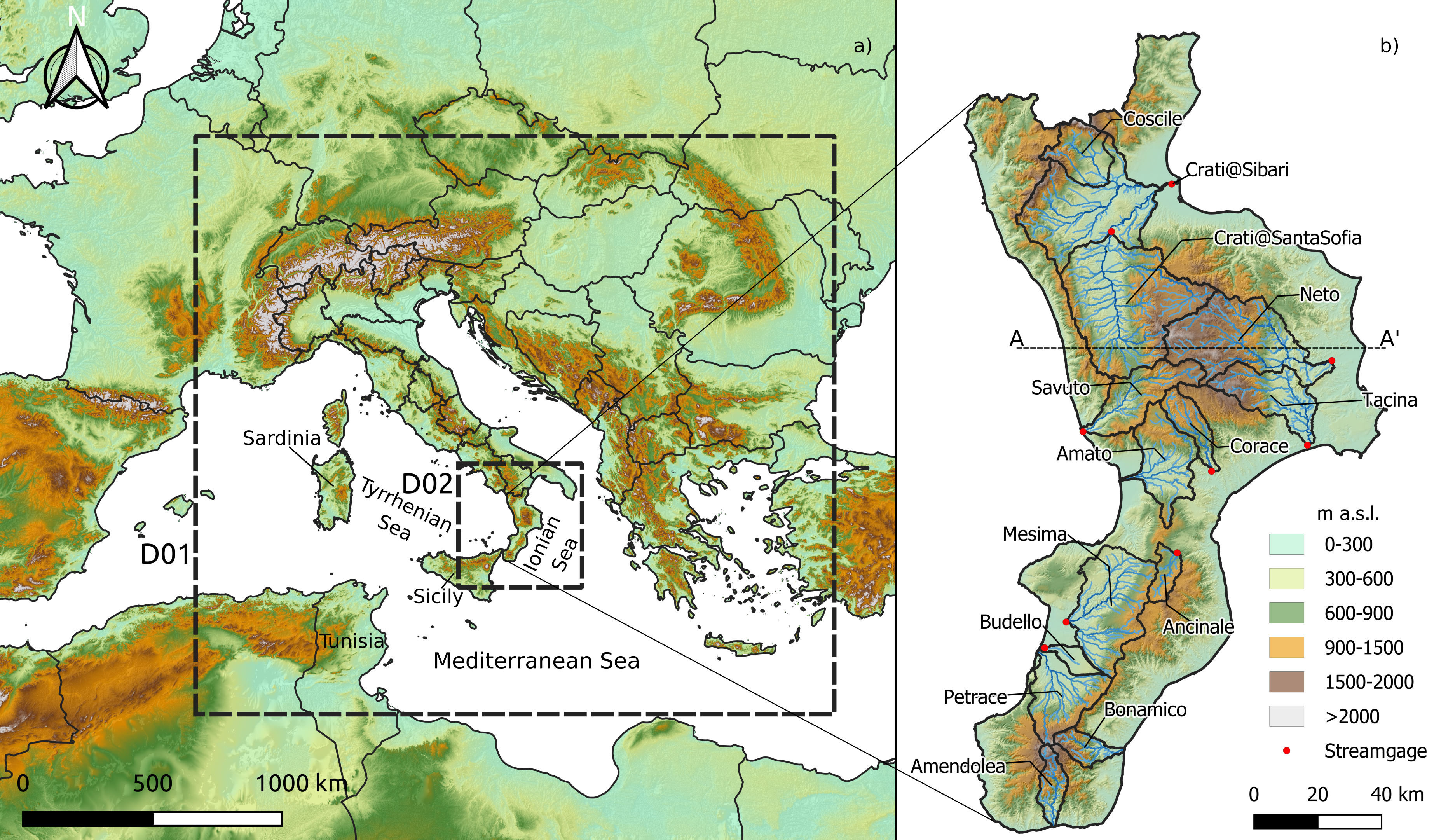
Fully coupled atmospheric-hydrological models allow a more realistic representation of the land surface–boundary layer continuum, representing both high-resolution land-surface/subsurface water lateral redistribution and the related feedback towards the atmosphere. This study evaluates the potential contribution of the fully coupled approach in extended-range mesoscale hydrometeorological ensemble forecasts. Previous studies have shown, for deterministic simulations, that the effect of fully coupling for short-range forecasts is minor compared to other sources of uncertainty, however, it becomes not negligible when increasing the forecast period. Through a proof-of-concept consisting of an ensemble (50 members from the ECMWF Ensemble Prediction System) seven-days-in-advance forecast of a high impact event affecting the Calabrian peninsula (southern Italy, Mediterranean basin) on November 2019, the paper elucidates the extent to which the improved representation of the terrestrial water lateral transport in the Weather Research and Forecasting (WRF) – Hydro modeling system affects the ensemble water balance, focusing on the precipitation and the hydrological response, in terms of both soil moisture dynamics and streamflow in 14 catchments spanning over 42% of the region. The fully coupled approach caused an increase of surface soil moisture and latent heat flux from land in the days preceding the event, partially affecting the lower Planetary Boundary Layer. However, when shoreward moisture transport from surrounding sea rapidly increased becoming the dominant process, only a weak signature of soil moisture contribution could be detected, resulting in only slightly higher precipitation forecast and not clear variation trend of peak flow, even though the latter variable increased up to 10% in some catchments. Overall, this study highlighted a remarkable performance of the medium-range ensemble forecasts, suggesting a profitable use of the fully coupled approach for forecasting purposes in circumstances in which soil moisture dynamics is more relevant and needs to be better addressed.