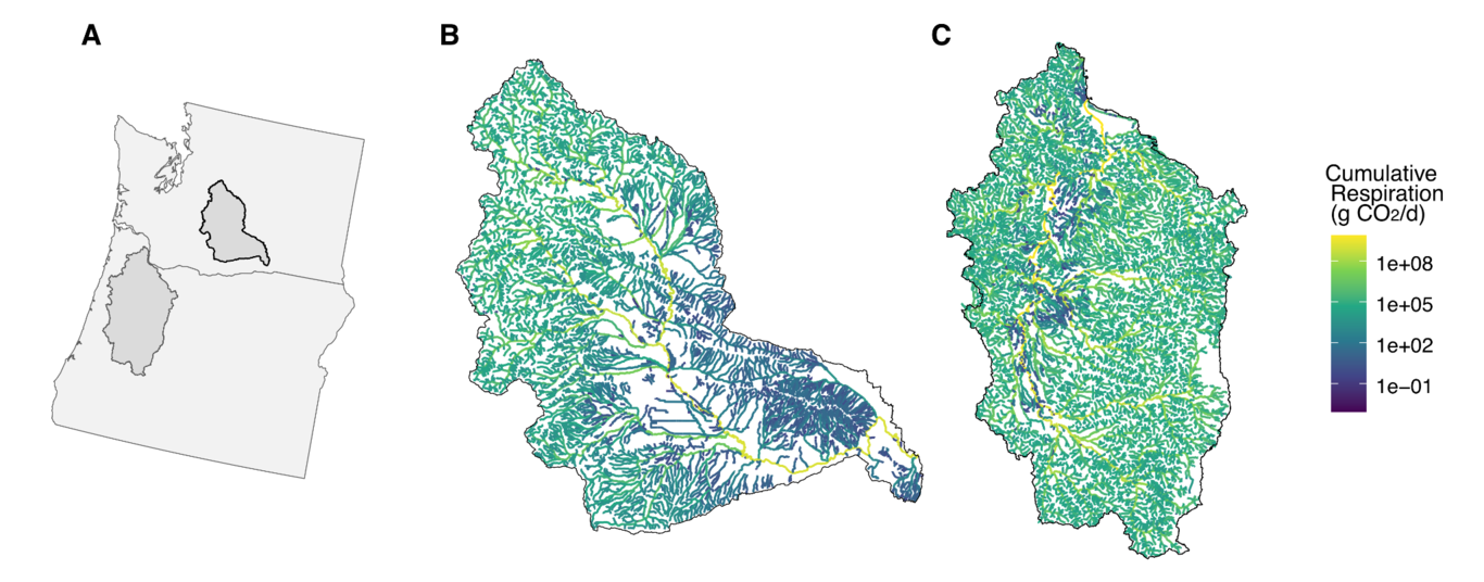
AUTHOREA
Log in Sign Up Browse Preprints
LOG IN SIGN UP

2081 hydrology Preprints

Related keywords
hydrology lumped vs distributed models segmented power law adaptation data-driven methods insurance control deuterium-excess near surface geophysics Rating curve saturated hydraulic conductivity information theory eucalyptus urophylla × e. grandis connectivity constant head test geography climate warming delft3d water isotope machine learning models spaef predictive performance braided river stem refilling tomography + show more keywords
hydrologic modelling Flood risk functional performance drainable pores transit time carbon flux climate flood remote sensing dual porosity geology river delta hydrologic modeling biological sciences environmental sciences machine learning soil moisture model inter-comparison clogging uncertainty assessment explainable AI parameterization rainfall-runoff groundwater parameter equivalence drought flash flood channel migration optimization recharge particle image velocimetry flood modeling soil sciences weathering multivariate drought index critical zone vegetation effect flash drought multiphase flow in porous media nocturnal transpiration vertical temperature profiler box aquifer informatics full waveform inversion avulsion observational uncertainty parameter calibration deforestation mhm water and sediment flux climatology (global change) geophysics spatial calibration streamgage groundwater-surface water exchange causal analysis geochemistry land use stable isotope ecology braiding intensity stochastic modelling remote sensing data groundwater age partially observable dynamical systems greenland sandy soil arctic atmospheric sciences disaster image processing (jaccard coefficient) nocturnal water use modelling and simulation frequency lao peoples democratic republic vpd bayesian soil water storage
FOLLOW
  • Email alerts
  • RSS feed
Please note: These are preprints and have not been peer reviewed. Data may be preliminary.
The Effect of Flood Exposure on Insurance Adoption among US Households
June Choi
Noah S. Diffenbaugh

June Choi

and 2 more

September 18, 2023
Despite increasing exposure to flooding and associated financial damages, estimates suggest more than two-thirds of flood-exposed properties are currently uninsured. This low adoption rate could undermine the climate resilience of communities and weaken the financial solvency of the United States National Flood Insurance Program (NFIP). We study whether repeated exposure to flood events, especially disaster-scale floods expected to become more frequent in a warming climate, could spur insurance adoption. Using improved estimates of residential insurance take-up in locations where such insurance is voluntary, and exploiting variation in the frequency and severity of flood events over time, we quantify how flood events impact local insurance demand. We find that a flood disaster declaration in a given year increases the take-up rate of insurance by 7% in the following year, but the effect diminishes in subsequent years and is gone after five years. This effect is more short-lived in counties in inland states that do not border the Gulf and Atlantic coasts. The effect of a flood on takeup is substantially larger if there was also a flood in the previous year. We also find that recent disasters are more salient for homeowners whose primary residences are exposed to a disaster declaration compared to non-primary residences. Our results provide a more comprehensive understanding of the salience effect of flooding on insurance demand compared to previous studies. Overall, these findings suggest that relying on households to self-adapt to increasing flood risks in a changing climate is insufficient for closing the insurance protection gap.
Large methane emissions from tree stems complicate the wetland methane budget
Luke Christopher Jeffrey
Charly Moras

Luke Christopher Jeffrey

and 8 more

September 13, 2023
Our understanding of tree stem methane (CH4) emissions is evolving rapidly. Few studies have combined seasonal measurements of soil, water and tree stem CH4 emissions from forested wetlands, inhibiting our capacity to constrain the tree stem CH4 flux contribution to total wetland CH4 flux. Here we present annual data from a subtropical freshwater Melaleuca quinquenervia wetland forest, spanning an elevational topo-gradient (Lower, Transitional and Upper zones). Eight field-campaigns captured an annual hydrological flood-dry-flood cycle, measuring stem fluxes on 30 trees, from four stem heights, and up to 30 adjacent soil or water CH4 fluxes per campaign. Tree stem CH4 fluxes ranged several orders of magnitude between hydrological seasons and topo-gradient zones, spanning from small CH4 uptake to ~203 mmol m-2 d-1. Soil CH4 fluxes were similarly dynamic and shifted from maximal CH4 emission (saturated soil) to uptake (dry soil). In Lower and Transitional zones respectively, tree stem CH4 contribution to the net ecosystem flux was greatest during flooded conditions (49.9 and 70.2 %) but less important during dry periods (3.1 and 28.2 %). Minor tree stem emissions from the Upper elevation zone still offset the Upper zone CH4 soil sink capacity by ~51% during dry conditions. Water table height was the strongest driver of tree stem CH4 fluxes, however tree emissions peaked once the soil was inundated and did not increase with further water depth. This study highlights the importance of quantifying the wetland tree stem CH4 emissions pathway as an important and seasonally oscillating component of wetland CH4 budgets.
Where in the world are vegetation patterns controlled by hillslope water dynamics?
Shuping Li
Dai Yamazaki

Shuping Li

and 3 more

September 13, 2023
Some recent land surface models can explicitly represent land surface process and focus more on sub-grid terrestrial features. Many studies have involved the analysis of how hillslope water dynamics determine vegetation patterns and shape ecologically and hydrologically important landscapes, such as desert riparian and waterlogged areas. However, the global locations and abundance of hillslope-dominated landscapes remain unclear. To address this knowledge gap, we propose a globally applicable method that employs high-resolution elevation, hydrography, and land cover data to neatly resolve explicit land cover heterogeneity for the mapping of hillslope-dominated landscapes. First, we aggregate pixels into unit catchments to represent topography-based hydrological units, and then vertically discretize them into height bands to approximate the hillslope profile. The dominant land cover type in each height band is determined, and the uphill land cover transition is analyzed to identify hillslope-dominated landscapes. The results indicate that hillslope-dominated landscapes are distributed extensively worldwide in diverse climate zones. Notably, some landscapes, including gallery forests in northeastern Russia and desert riparian in the Horn of Africa, are newly revealed. Furthermore, the proposed strategy enables more accurate representation of explicit land cover heterogeneity than does the simple downscaling of a rectangular grid from larger to smaller units, revealing its capability to neatly resolve land cover heterogeneity in land surface modeling with relatively high accuracy. Overall, we present the extensive global distribution of landscapes shaped by hillslope water dynamics, underscoring the importance of the explicit resolution of heterogeneity in land surface modeling.
Examining long-term variability in saturated hydraulic conductivity of sandy soils an...
Saeed Nikghalb Ashouri
Adrian Pittari

Saeed Nikghalb Ashouri

and 3 more

September 13, 2023
Saturated hydraulic conductivity (Ks) is a crucial parameter that influences water flow in saturated soils, with applications in various fields such as surface water runoff, soil erosion, drainage, and solute transport. However, accurate estimation of Ks is challenging due to temporal and spatial uncertainties. This study addresses the knowledge gap regarding the long-term behaviour of Ks in sandy soils with less than 10% fine particles. The research investigates the changes in Ks over a long period of constant head tests and examines the factors influencing its variation. Two sandy samples were tested using a hydraulic conductivity cell, and the hydraulic head and discharge were recorded for over 50 days. The results show a general decline in Ks throughout the test, except for brief periods of increase. Furthermore, the relationship between flow rate and hydraulic head gradient does not follow the expected linear correlation from Darcy’s law, highlighting the complex nature of sandy soil hydraulic conductivity. The investigation of soil properties in three different sections of the samples before and after the tests revealed a decrease in the percentage of fine particles and a shift in specific gravity from the bottom to the top of the sample, suggesting particle migration along the flow direction. Factors such as clogging by fine particles and pore pressure variation contribute to the changes in Ks. The implications of this study have far-reaching effects on various geotechnical engineering applications. These include groundwater remediation, geotechnical stability analysis, and drainage system design.
First order controls of avulsion in river deltas
Octria Adi Prasojo
Trevor B. Hoey

Octria Adi Prasojo

and 3 more

September 13, 2023
Changed hydrological regimes, sea-level rise, and accelerated subsidence are all putting river deltas at risk across the globe. Deltas may respond to these stressors through the mechanism of avulsion. Decades of delta avulsion studies have resulted in conflicting hypotheses that avulsion frequency and location are upstream (water and sediment discharge) or downstream (backwater and sea-level rise) controlled. In this study, we use Delft3D morphodynamic simulations to investigate the main controls over delta avulsion. Avulsion timing and location were recorded in six scenarios modelled over a 400-year period with varying alluvial slopes upstream of a delta slope break (1.13x10⁻⁴ to 3.04x10⁻³) within a range representative global deltas. We measure several independent morphometric variables including avulsion length, delta lobe width, channel width at avulsion, delta topset slope and sediment load. Correlating these variables with the avulsion timescales observed in our model shows that avulsion timescale is mostly controlled by sediment load, which in turn is controlled by the alluvial slope upstream of a delta slope break. With higher stream power index in steeper alluvial slopes, more sediment can be carried within a channel, resulting in more frequent avulsions. Our results are consistent with the avulsion timescale derived from an analytical solution, 19 natural deltas and downscaled physical laboratory deltas. These results help mitigate delta avulsion risk by focusing management efforts on variables that primarily control avulsion in a river delta, but also induce further debate over whether sea-level rise may, or may not, trigger more avulsions in river deltas.
Causal Drivers of Land-Atmosphere Carbon Fluxes from Machine Learning Models and Data
Mozhgan A Farahani
Allison Eva Goodwell

Mozhgan A Farahani

and 1 more

September 13, 2023
Interactions among atmospheric, root-soil, and vegetation processes drive carbon dioxide fluxes (Fc) from land to atmosphere. Eddy covariance measurements are commonly used to measure Fc at sub-daily timescales and validate process-based and data-driven models. However, these validations do not reveal process interactions, thresholds, and key differences in how models replicate them. We use information theory-based measures to explore multivariate information flow pathways from forcing data to observed and modeled hourly Fc, using flux tower datasets in the Midwestern U.S. in intensively managed corn-soybean landscapes. We compare Multiple Linear Regressions (MLR), Long-Short Term Memory (LSTM), and Random Forests (RF) to evaluate how different model structures use information from combinations of sources to predict Fc. We extend a framework for model predictive performance and functional performance, which examines the full suite of dependencies from all forcing variables to the observed or modeled target. Of the three model types, RF exhibited the highest functional and predictive performance. Regionally trained models demonstrate lower predictive but higher functional performance compared to site-specific models, suggesting superior reproduction of observed relationships. This study shows that some metrics of predictive performance encapsulate functional behaviors better than others, highlighting the need for multiple metrics of both types. This study improves our understanding of carbon fluxes in an intensively managed landscape, and more generally provides insight into how model structures and forcing variables translate to interactions that are well versus poorly captured in models.
Catchment properties shape seasonal variation in groundwater- surface water interacti...
Lars Bäthke
Tobias Schuetz

Lars Bäthke

and 1 more

September 13, 2023
The cumulative and bidirectional groundwater-surface water (GW-SW) interaction along a stream is defined as hydrological turnover (HT) influencing solute transport and source water composition. However, HT proves to be highly variable, producing spatial exchange patterns influenced by local surface- and groundwater levels, geology and topography. Hence, identifying factors controlling HT in streams poses a challenge. We studied the spatiotemporal variability of HT processes at a third order tributary of the river Mosel, Germany at two different stream reaches over a period of two years. Additionally, we sampled for silicate concentrations in the stream as well as in the near-stream groundwater. Thus, creating snapshots of the boundary layer between ground- and surface water where turnover induced mixing occurs. We characterize reach specific drainage behavior by utilizing a delayed/base flow separation analysis for both reaches. The results show a site-specific negative correlation of HT with discharge, while hydraulic gradients and reach scale absolute discharge changes correlating with HT only at the upstream site which is characterized by steeper hillslopes compared to the downstream section. Analyzing the variation of silicate concentrations between stream and wells shows that in-reach silicate variation increases significantly with the decrease of HT under groundwater dominated flow conditions.. In Summary, our results show that discharge shapes the influence of HT on solute transport as visualized by silicate variations. Yet, reach specific drainage behavior shapes seasonal states of groundwater storages and thus, can be an additional control of HT magnitudes, influencing physical stream water composition throughout the year.
The physics behind groundwater recession and hydrologically passive mixing volumes.
Baibaswata Bhaduri
Ophélie Fovet

Baibaswata Bhaduri

and 3 more

September 11, 2023
To estimate groundwater flow and transport, lumped conceptual models are widely used due to their simplicity and parsimony - but these models are calibration reliant as their parameters are unquantifiable through measurements. To eliminate this inconvenience, we tried to express these conceptual parameters in terms of hydrodynamic aquifer properties to give lumped models a forward modelling potential. The most generic form of a lumped model representing groundwater is a unit consisting of a linear reservoir connected to a dead storage aiding extra dilution, or a combination of several such units mixing in calibrated fractions. We used one such standard two-store model as our test model, which was previously nicely calibrated on the groundwater flow and transport behaviour of a French agricultural catchment. Then using a standard finite element code, we generated synthetic Dupuit-Forchheimer box aquifers and calibrated their hydrodynamic parameters to exactly match the test model’s behaviour (concentration, age etc). The optimized aquifer parameters were then compared with conceptual parameters to find clear physical equivalence and mathematical correlation - we observed that the recession behaviour depends on the conductivity, fillable porosity, and length of the catchment whereas the mixing behaviour depends on the total porosity and mean aquifer thickness. We also noticed that for a two-store lumped model, faster and slower store represents differences only in porosities making it rather a dual porosity system. We ended with outlining a clear technique on using lumped models to run forward simulations in ungauged catchments where valid measurements of hydrodynamic parameters are available.
Developing a Multivariate Agro-Meteorological Index to Improve Capturing Onset and Pe...
Masoud Zeraati
Alireza Farahmand

Masoud Zeraati

and 3 more

September 11, 2023
Drought is associated with adverse environmental and societal impacts across various regions. Therefore, drought monitoring based on a single variable may lead to unreliable information, especially about the onset and persistence of drought. Previous studies show vapor pressure deficit (VPD) data can detect drought onset earlier than other drought indicators such as precipitation. On the other hand, Soil Moisture is a robust indicator for assessing drought persistence. This study introduces a nonparametric multivariate drought index Vapor Pressure Deficit Soil moisture standardized Drought Index (VPDSDI) which is developed by combining vapor pressure deficit (VPD) with soil moisture information. The performance of the multivariate index in terms of drought onset detection is compared with the Standardized Precipitation Index (SPI) for six major drought events across the United States including three flash drought events and three conventional drought events. Additionally, the performance of the proposed index in detecting drought persistence is compared with the Standardized Soil moisture Index (SSI), which is an agricultural drought index. Results indicate the multivariate index detects drought onset always earlier than SPI for conventional events, but VPDSDI detects drought onset earlier than or about the same time as SPI for flash droughts. In terms of persistence, VPDSDI detects persistence almost identical to SSI for both flash and conventional drought events. The results also show that combining VPD with soil moisture reduces the high variability of VPD and produces a smoother index which improves the onset and persistence detection of drought events leveraging VPD and soil moisture information.
Generating interpretable rainfall-runoff models automatically from data
Travis Adrian Dantzer
Branko Kerkez

Travis Adrian Dantzer

and 1 more

September 11, 2023
A sudden surge of data has created new challenges in water management, spanning quality control, assimilation, and analysis. Few approaches are available to integrate growing volumes of data into interpretable results. Process-based hydrologic models have not been designed to consume large amounts of data. Alternatively, new machine learning tools can automate data analysis and forecasting, but their lack of interpretability and reliance on very large data sets limits the discovery of insights and may impact trust. To that end, we present a new approach, which seeks to strike a middle ground between process-, and data-based modeling. The contribution of this work is an automated and scalable methodology that discovers differential equations and latent state estimations within hydrologic systems using only rainfall and runoff measurements. We show how this enables automated tools to learn interpretable models of 6 to 18 parameters solely from measurements. We apply this approach to nearly 400 stream gaging sites across the US, showing how complex catchment dynamics can be reconstructed solely from rainfall and runoff measurements. We also show how the approach discovers surrogate models that can replicate the dynamics of a much more complex process-based model, but at a fraction of the computational complexity. We discuss how the resulting representation of watershed dynamics provides insight and computational efficiency to enable automated predictions across large sensor networks.
Novel hypothesis on the occurrence of sandbars
shohei seki

shohei seki

and 3 more

September 11, 2023
The mechanism of sandbars initiation and formation is unresolved. The occurrence of sandbars has been investigated using stability analysis, which assumes that sandbars occur due to the inherent instability of a riverbed. However, there are no data, either from riverine observations or model experiments, to support this assumption. Here, we conducted flume experiments in which sandbars were formed from a flatbed by simultaneously measuring the water surface and bottom surface. The results showed that the process of sandbars initiation and formation first involves the generation of small periodic bedforms; then, the bedforms transition to small three-dimensionally shaped rhomboid bars, and finally the rhomboid bars transition to sandbars. The measurements also suggested that wave trains occurred on the water surface. We then conducted fixed-bed experiments under the same conditions as a moving bed to ascertain the behavior of the water surface. The results of these fixed-bed experiments showed that standing waves were observed on the water surface even when the experimental conditions were steady and the flatbed channel was straight. A two-dimensional wavenumber analysis showed that the dominant wavenumbers of the standing waves and initial small bedforms were in good agreement. The whole set of results indicated that standing waves were already present on the water surface before bedforms occurred and that one of the factors in sandbars initiation was the presence of standing waves on the water surface.
Quantification of nocturnal water use and its composition in a Eucalyptus urophylla ×...
chao zhi wang
Apeng Du

chao zhi wang

and 5 more

September 11, 2023
Nocturnal water use (Qnight) is an important component of the eucalyptus water budget, but it has always been under-appreciated and poorly understood. To improve the accuracy of water balance estimates and understanding of the nocturnal water use process in eucalypts plantations, we conducted a 3-year study to investigate the characteristics of Qnight and its components in a Eucalyptus urophylla × E.grandis plantation in southern China. The results showed that the Qnight of E.urophylla × E.grandis was substantial and its contribution (Rnight) to daily water use (Qdaily) was on average 12.35%, with higher Rnight (14.97%) in the dry season than in the wet season (9.50%). However, the Qnight was used not only for nocturnal transpiration (Tn), but also for stem refilling (Re). Tn was influenced by a combination of vapor pressure deficit (VPD), air temperature (Ta) and relative humidity (RH), with VPD being the dominant driver. Based on this, combined with the fact that Re was closely related to diurnal variations in diameter, we have developed a novel method to distinguish Tn from Re. We found that the compositional ratios of Tn and Re differed between weather conditions and months. However, on a 3-year average, Qnight of E.urophylla × E.grandis was still mainly used for Tn (58.63%). Our results highlight the non-ignorability of Qnight and the high variability of the compositional ratios of Re and Tn, and suggest that Qnight and its components should be accurately quantified and taken into account when studying the water balance in eucalyptus stands.
Evaporation and water sourcing dominate lake and stream isotopic variability across t...
Pete D. Akers
Ben Gordon Kopec

Pete D. Akers

and 3 more

September 11, 2023
Rapidly changing climate is disrupting the High Arctic’s natural water systems. This disruption demands high quality monitoring of Arctic hydrology to better reconstruct past changes, track ongoing transformations, and assess future environmental threats. Water isotopes are valuable tracers of hydrological processes, but logistical challenges limit the length and scope of isotopic monitoring in High Arctic landscapes. Here, we present a comprehensive isotopic survey of 535 water samples taken in 2018–2019 of the lakes, streams, and other surface waters of the periglacial Pituffik Peninsula in far northwest Greenland. The δ18O, δ2H, and deuterium-excess values of these samples, representing 196 unique sites, grant us unprecedented insight into the environmental drivers of the region’s hydrology and water isotopic variability. We find that the spatial and temporal variability of lake isotopes is dominated by evaporation and connectivity to summer meltwater sources, while evaporation determines interannual isotopic changes. Stream isotopic compositions vary in both space and time based on the relative source balance of tundra snowpack meltwater versus surface melt from the nearby Greenland Ice Sheet. Overall, our survey highlights the diversity of isotopic composition and evolution in Pituffik surface waters, and our complete isotopic and geospatial database provides a strong foundation for future researchers to study hydrological changes at Pituffik and across the Arctic. Water isotope samples taken at individual times or sites in similar periglacial landscapes likely have limited regional representativeness, and increasing the spatiotemporal extent of isotopic sampling is critical to producing accurate and informative High Arctic paleoclimate reconstructions.
Channel morphological activation of large braided rivers in response to climate-drive...
Zhiwei Li
Yuchong He

Zhiwei Li

and 2 more

September 11, 2023
With the rising air temperature and precipitation, water and sediment flux in the Source Region of the Yangtze River have increased significantly since 2000. Nonetheless, the response of braided river morphology to climate-driven water and sediment flux change is still unknown. Water bodies of nine large braided rivers from 1990 to 2020 were extracted based on Google Earth Engine platform, and impacts of climate change on activation indices of braided river morphology were quantified. The main results are presented that a new method of braided water body extraction by combining Lowpath algorithm and Local Otsu algorithm is firstly proposed, which reduces 59% of the root mean squared error of braiding intensity in comparison with the Global Otsu method. The braiding intensity has a parabolic variation trend with the water area ratio, and the average sandbar area ratio has a negative power law trend with the water area ratio. Intra-annual channel migration intensity has an obvious temporal scale effect, which increases rapidly when the time span is less than 5 years. The warming and wetting trend led to vegetation cover increasing significantly. With the increase of runoff, water area of each braided reach has increased in both flood and non-flood season. Intra-annual channel migration intensity shows three different trends of increasing, weakening, and unchanged over time. The response of migration intensity to climate warming can be classified into three patterns in the SRYR as follows: sediment increase constrained pattern, sediment increase dominated pattern, and runoff increase dominated pattern.
Challenges in the attribution of river flood events
Paolo Scussolini

Paolo Scussolini

and 10 more

August 29, 2023
Preprint, August 28th 2023Authors: Paolo Scussolini1*, Linh N. Luu2,3,4, Sjoukje Y. Philip4, Wouter R. Berghuijs5, Dirk Eilander1,6, Jeroen C.J.H. Aerts1, Sarah F. Kew4, Geert Jan van Oldenborgh4† , Willem H.J. Toonen5, Jan Volkholz7, Dim Coumou1,41Institute for Environmental Studies, Vrije Universiteit Amsterdam, Netherlands2Department of Geography, University of Lincoln, United Kingdom3Vietnam Institute of Meteorology, Hydrology and Climate Change, Hanoi, Vietnam4Royal Netherlands Meteorological Institute, Netherlands5Department of Earth Science, Vrije Universiteit Amsterdam, Netherlands6Deltares, Netherlands7Potsdam Institute for Climate Impact Research, Germany*Corresponding author: p.scussolini@vu.nl† Deceased, October 12th2021
Comparison of Four Competing Invasion Percolation Models for Gas Flow in Porous Media
Ishani Banerjee
Anneli Guthke

Ishani Banerjee

and 4 more

September 08, 2023
Numerous variations of Invasion-Percolation (IP) models can simulate multiphase flow in porous media across various scales (pore-scale IP to macroscopic IP); here, we are interested in gas flow in water-saturated porous media. This flow occurs either as continuous or discontinuous flow, depending on the flow rate and the porous medium’s nature. Literature suggests that IP models are well suited for the discontinuous gas flow regime; other flow regimes have not been explored. Our research compares four existing macroscopic IP models and ranks their performance in these “other” flow regimes. We test the models on a range of gas-injection in water-saturated sand experiments from transitional and continuous gas flow regimes. Using the light transmission technique, the experimental data is obtained as a time series of images in a 2-dimensional setup. To represent pore-scale heterogeneities, we ran each model version on several random realizations of the initial entry pressure field. We use a diffused version of the so-called Jaccard coefficient to rank the models against the experimental data. We average the Jaccard coefficient over all realizations per model version to evaluate each model and calibrate specific model parameters. Depending on the application domain, we observe that some macroscopic IP model versions are suitable in these previously unexplored flow regimes. Also, we identify that the initial entry pressure fields strongly affect the performance of these models. Our comparison method is not limited to gas-water systems in porous media but generalizes to any modelling situation accompanied by spatially and temporally highly resolved data.
Near-Surface Full-Waveform Inversion Reveals Bedrock Controls on Critical Zone Archit...
Benjamin J Eppinger
W. Steven Holbrook

Benjamin J Eppinger

and 4 more

August 24, 2023
For decades, seismic imaging methods have been used to study the critical zone, Earth's thin, life-supporting skin. The vast majority of critical zone seismic studies use traveltime tomography, which poorly resolves heterogeneity at many scales relevant to near-surface processes, therefore, limiting progress in critical zone science. Full-waveform inversion can overcome this limitation by leveraging more of the seismic waveform and enhancing the resolution of geophysical imaging. In this study, we apply full-waveform inversion to elucidate previously undetected heterogeneity in the critical zone at a well-studied catchment in the Laramie Range, Wyoming. In contrast to traveltime tomograms from the same data set, our results show variations in depth to bedrock ranging from 5 to 60 meters over lateral scales of just tens of meters and image steep low-velocity anomalies suggesting hydrologic pathways into the deep critical zone. Our results also show that areas with thick fractured bedrock layers correspond to zones of slightly lower velocities in the deep bedrock, while zones of high bedrock velocity correspond to sharp vertical transitions from bedrock to saprolite. By corroborating these findings with borehole imagery, we hypothesize that lateral changes in bedrock fracture density majorly impact critical zone architecture. Borehole data also show that our full-waveform inversion results agree significantly better with velocity logs than previously published traveltime tomography models. Full-waveform inversion thus appears unprecedently capable of imaging the spatially complex porosity structure crucial to critical zone hydrology and processes.
Tradeoffs  between temporal and spatial pattern calibration and their impacts on robu...
Mehmet Cüneyd Demirel

Mehmet Cüneyd Demirel

and 8 more

August 24, 2023
Optimization of spatially consistent parameter fields is believed to increase the robustness of parameter estimation and its transferability to ungauged basins. The current paper extends previous multi-objective and transferability studies by exploring the value of both multi-basin and spatial pattern calibration of distributed hydrologic models as compared to single-basin and single-objective model calibrations, with respect to tradeoffs, performance and transferability. The mesoscale Hydrological Model (mHM) is used across six large central European basins. Model simulations are evaluated against daily streamflow observations at the basin outlets and remotely sensed evapotranspiration patterns obtained with a two-source energy balance approach. Several model validation experiments are performed through combinations of single- (discharge) and multi-objective (discharge and spatial evapotranspiration patterns) calibrations with holdout experiments saving alternating basins for model evaluation. The study shows that there are very minimal tradeoffs between spatial and temporal performance objectives and that a joint calibration of multiple basins using multiple objective functions provides the most robust estimations of parameter fields that perform better when transferred to ungauged basins. The study indicates that particularly the multi-basin calibration approach is key for robust parametrizations, and that the addition of an objective function tailored for matching spatial patterns of ET fields alters the spatial parameter fields while significantly improving the spatial pattern performance without any tradeoffs with discharge performance. In light of model equifinality, the minimal tradeoff between spatial and temporal performance shows that adding spatial pattern evaluation to the traditional temporal evaluation of hydrological models can assist in identifying optimal parameter sets.
Distributed Flashiness-Intensity-Duration-Frequency products over the conterminous US
Zhi Li
Shang Gao

Zhi Li

and 10 more

August 22, 2023
Effective flash flood forecasting and risk communication are imperative for mitigating the impacts of flash floods. However, the current forecasting of flash flood occurrence and magnitude largely depends on forecasters’ expertise. An emerging flashiness-intensity-duration-frequency (F-IDF) product is anticipated to facilitate forecasters by quantifying the frequency and magnitude of an imminent flash flood event. To make this concept usable, we develop two distributed F-IDF products across the contiguous US, utilizing both a Machine Learning (ML) approach and a physics-based hydrologic simulation approach that can be applied at ungaged pixels. Specifically, we explored 20 common ML methods and interpreted their predictions using the Shapley Additive exPlanations method. For the hydrologic simulation, we applied the operational flash flood forecast framework – EF5/CREST. It is found that: (1) both CREST and ML depict similar flash flood hot spots across the CONUS; (2) The ML approach outperforms the CREST-based approach, with the drainage area, air temperature, channel slope, potential evaporation, soil erosion identified as the five most important factors; (3) The CREST-based approach exhibits high model bias in regions characterized by dam/reservoir regulation, urbanization, or mild slopes. We discuss two application use cases for these two products. The CREST-based approach, with its dynamic streamflow predictions, can be integrated into the existing real-time flash flood forecast system to provide event-based forecasts of the frequency and intensity of floods at multiple durations. On the other hand, the ML-based approach, which is a static measure, can be integrated into a flash flood risk assessment framework for urban planners.
Satellite video remote sensing for estimation of river discharge
Christopher Masafu

Christopher Masafu

September 11, 2023
Authors and affiliationsChristopher Masafu1, Richard Williams1, Martin D. Hurst11School of Geographical and Earth Sciences, University of Glasgow, Glasgow, G12 8QQ, UKCorresponding Author: Christopher Masafu (christopher.masafu@glasgow.ac.uk)
Advancing Heat-as-a-Tracer Groundwater Flux Estimates in Preferential Discharge Zones...
Robert Sohn
Martin Briggs

Robert Sohn

and 2 more

August 21, 2023
Preferential groundwater discharge zones are critical to a wide range of surface water habitat and water quality processes, but they can be difficult to characterize due to strong spatial variability in flux rate and high attenuation of natural temperature signals. As such, passive heat-as-a-tracer methods employing Vertical Temperature Profiler data are often ill-suited for quantifying vertical discharge flux rates due to a combination of inadequate sensor distribution and resolution paired with analytical modeling methods based on diurnal signals only. Using data from a site of contaminant-loaded groundwater discharge to the Quashnet River on Cape Cod, Massachusetts, USA, we demonstrate how coupled improvements in instrumentation and parameter estimation methods can largely alleviate these issues. Consequently, more accurate groundwater flux estimates, including temporal variations, are now possible at sites of strong discharge using passive heat-as-a-tracer methods.
A simple parameterization for segmented rating curves
Timothy Hodson
Terry Kenney

Timothy O Hodson

and 3 more

August 21, 2023
Streamflow is one of the most important variables in hydrology but is difficult to measure continuously. As a result, nearly all streamflow time series are estimated from rating curves that define a mathematical relationship between streamflow and some easy-to-measure surrogate like water-surface elevation (stage). Most ratings are still fit manually, which is time-consuming and subjective. To improve that process, the U.S. Geological Survey (USGS), among others, is evaluating algorithms to automate that fitting. Several automated methods already exist, and each parameterizes the rating curve slightly differently. Because of the nonconvex nature of the problem, those differences can greatly affect performance. After some trial and error, we settled on reparameterizing the classic segmented power law somewhat like a Bayesian physics-informed neural network. Being physics-informed and Bayesian, the algorithm requires minimal data and also estimates uncertainty. Its implementation is open source and easily modified so that others can contribute to improving the quality of USGS streamflow data.
Double Mass Plots reveal a marked decrease in the water yield of a Lower Mekong River...
Edward B. Wronski
Neil C. Turner

Edward B. Wronski

and 1 more

September 11, 2023
In most, but not all of the scientific literature, cutting of forested watershed results in an increase in water yield of a watershed. In this study, a double-mass plot of the cumulative monthly flow of water between 1961 and 2000, from a 79,000 km2 (7.9 million ha) forested watershed feeding into the Mekong River, on cumulative monthly precipitation over the same period, was used to demonstrate a significant decrease in the water yield in 1985. For 10-12 years after 1985, the total water yield from the watershed decreased by 42% (256 mm) while the late (March and April) dry-season flow decreased by almost 80%. From the changes in water yield and an understanding of the local hydrology, we calculated that 75-80% of the forested area was cut, i.e. more than 6 million ha, implying that the decrease in total water yield from the area of the forest that was actually cut, was just over 50%, while the late dry-season flow from the same area was virtually eliminated. We consider that the main reason for the reduction in water yield, after the forest was cut was an immediate increase in dry-season transpiration by the remaining old forest, newly-exposed understorey and regrowth vegetation, all of which were considered to be accessing groundwater in the regolith. The amount of groundwater accessed was sufficient to allow the cut forest to lose water at the potential rate over the whole year. We conclude that restoration of the watershed water flows resulted mainly from forest regrowth.
Multi-language retrieval of United States hydrologic data
Timothy Hodson

Timothy Hodson

and 6 more

August 21, 2023
A document by Timothy Hodson. Click on the document to view its contents.
← Previous 1 2 3 4 5 6 7 8 9 … 86 87 Next →
Back to search
Authorea
  • Home
  • About
  • Product
  • Preprints
  • Pricing
  • Blog
  • Twitter
  • Help
  • Terms of Use
  • Privacy Policy